Elevated Fire Risk Tri-State: 7 Safety Tips

Elevated Fire Risk Tri-State: 7 Safety Tips

Elevated Fire Risk Tri-State: 7 Safety Tips

Tri-State Area on High Alert: Fire Risk Soars Amidst Dry, Breezy Weather

Introduction: A Perfect Storm for Wildfires?

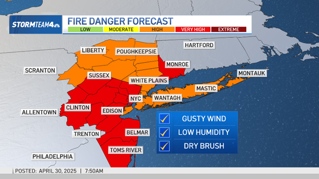
Hold onto your hats, folks! Wednesday's weather across the tri-state area is shaping up to be a real mixed bag. While we can expect comfortable temperatures and sunshine, there's a hidden danger lurking: an elevated risk of fire spread. Think of it as a seemingly innocent day with a potentially fiery secret.

The Dry and Breezy Culprits

What exactly is causing this heightened fire risk? It boils down to two main factors: low humidity and brisk winds. Let’s break down each one:

Low Humidity: The Thirsty Atmosphere

Low humidity essentially means that the air is very dry. This dry air sucks moisture out of everything around it, including vegetation. Think of it like a sponge left out in the sun – it quickly becomes brittle and easily crumbled. The same thing happens to dry brush and grasses, making them highly flammable.

Brisk Northwest Winds: Fueling the Flames

Adding fuel to the fire – quite literally – are the expected brisk northwest winds. These winds can quickly spread any flames that ignite, turning a small spark into a raging wildfire in a matter of minutes. Imagine a bellows being used to fan the flames of a fireplace – that's essentially what these winds are doing.

Official Warnings: Heed the Call

The National Weather Service is taking this threat seriously and has issued warnings urging residents to exercise extreme caution. "Exercise caution handling any potential ignition sources, including machinery, cigarettes, and matches. Any fires that ignite will have the potential to spread quickly," they warn. This isn't just a friendly reminder; it's a call to action.

Potential Ignition Sources: What to Watch Out For

Knowing the potential ignition sources is crucial in preventing wildfires. Here are some key areas to focus on:

Machinery: Sparks Can Fly

Lawnmowers, chainsaws, and other power equipment can easily spark a fire, especially when used on dry vegetation. Make sure your equipment is properly maintained and avoid using it during the hottest and driest parts of the day.

Cigarettes: A Careless Flick Can Cause Catastrophe

Improperly discarded cigarettes are a major cause of wildfires. Always extinguish cigarettes completely in a designated ashtray and never toss them out of a car window.

Matches and Open Flames: Handle with Care

Matches, lighters, and campfires should be handled with extreme care. Never leave a campfire unattended and make sure it's completely extinguished before leaving the area.

Protecting Your Property: Simple Steps, Big Impact

Taking preventative measures around your property can significantly reduce the risk of fire damage. Here are a few things you can do:

Creating Defensible Space: A Buffer Zone

Clear away dry brush, leaves, and other flammable materials from around your home. This creates a buffer zone that can help slow or stop the spread of a wildfire. Think of it as building a moat around your castle – it provides a crucial layer of protection.

Maintaining Your Lawn: Keep it Trimmed

Keep your lawn mowed and watered to prevent it from becoming dry and flammable. A healthy lawn is a less inviting target for wildfires.

Cleaning Gutters and Roofs: Removing Fuel

Clean out your gutters and roofs regularly to remove accumulated leaves and debris that can easily ignite. These areas are like tinderboxes waiting for a spark.

Community Awareness: Spread the Word, Not the Flames

It's important to raise awareness within your community about the elevated fire risk. Share this information with your neighbors and encourage them to take preventative measures as well. We're all in this together, and collective action is key to preventing wildfires.

Emergency Preparedness: Knowing What to Do

In the unfortunate event that a fire does break out, it's important to have an emergency plan in place. Here's what you should do:

Evacuation Plan: Know Your Route

Develop an evacuation plan and practice it with your family. Make sure everyone knows the designated meeting point and the safest route to get there.

Emergency Kit: Essential Supplies

Prepare an emergency kit with essential supplies such as water, food, first-aid supplies, and a battery-powered radio. Having these supplies on hand can make a big difference in a crisis.

Stay Informed: Monitor the Situation

Stay informed about the latest weather updates and fire conditions by monitoring local news and weather channels. Knowledge is power, especially in an emergency.

Long-Term Outlook: Climate Change and Fire Risk

It's important to recognize that climate change is exacerbating the risk of wildfires in many areas. As temperatures rise and droughts become more frequent, dry vegetation becomes even more susceptible to ignition. Addressing climate change is crucial in mitigating the long-term risk of wildfires.

Regional Variations: Fire Danger Across the Tri-State Area

While the elevated fire risk applies to the entire tri-state area, some regions may be more vulnerable than others due to local conditions. Pay attention to local news and weather reports for specific information about your area.

Resources and Support: Where to Turn for Help

There are numerous resources available to help you prepare for and respond to wildfires. Contact your local fire department, emergency management agency, or the National Weather Service for information and assistance.

The Importance of Reporting: See Something, Say Something

If you see smoke or fire, report it immediately to your local fire department. Early detection and reporting can make a crucial difference in containing a wildfire. Don't hesitate – every second counts.

Conclusion: Stay Vigilant and Stay Safe

Wednesday's dry, breezy weather brings an elevated risk of fire spread across the tri-state area. By exercising caution, taking preventative measures, and staying informed, we can all help prevent wildfires and protect our communities. Remember, fire safety is a shared responsibility. Stay vigilant and stay safe!

Frequently Asked Questions (FAQs)

  1. What exactly does "elevated fire risk" mean? It means the conditions are ripe for wildfires to start easily and spread quickly due to dry vegetation, low humidity, and wind. It's a warning to be extra cautious with anything that could spark a flame.
  2. How can I tell if the fire risk is high in my specific area? Check your local news, weather forecasts, and the National Weather Service website for specific fire weather warnings or red flag alerts. These alerts will detail the level of risk in your region.
  3. What's the best way to dispose of charcoal after grilling? Allow the charcoal to cool completely (at least 48 hours). Then, soak it in water before disposing of it in a metal container. Never dump hot charcoal in a wooded area or trash can.
  4. What kind of plants are best to use in landscaping to reduce fire risk? Choose drought-tolerant, fire-resistant plants like succulents, rockrose, and some types of shrubs. Avoid planting highly flammable plants like pine trees or juniper bushes near your home.
  5. If I see a fire, what information should I give to the 911 operator? Provide the exact location of the fire (address or landmarks), the size of the fire, what is burning (grass, trees, building), and whether there are any structures or people in danger.
Florida Bear Attack: Man and Dog Killed - What You Must Know

Florida Bear Attack: Man and Dog Killed - What You Must Know

Florida Bear Attack: Man and Dog Killed - What You Must Know

Tragedy in Florida: Bear Attack Kills Man and Beloved Dog

A Southwest Florida Nightmare: Introduction

Imagine waking up to news that shatters the tranquility of your community. That's precisely what happened in southwest Florida, near Jerome in Collier County. A shocking incident has left residents reeling after an 89-year-old man, Robert Markel, and his loyal canine companion were found dead in a suspected bear attack. Can you imagine the horror? What should have been a peaceful morning turned into a nightmare scenario, prompting a full-scale investigation by the Florida Fish and Wildlife Conservation Commission (FWC) and local law enforcement. This isn't just a news story; it's a stark reminder of the wildness that still exists alongside our suburban lives. Let's delve into the details and understand what we know so far.

The Grim Discovery: What We Know

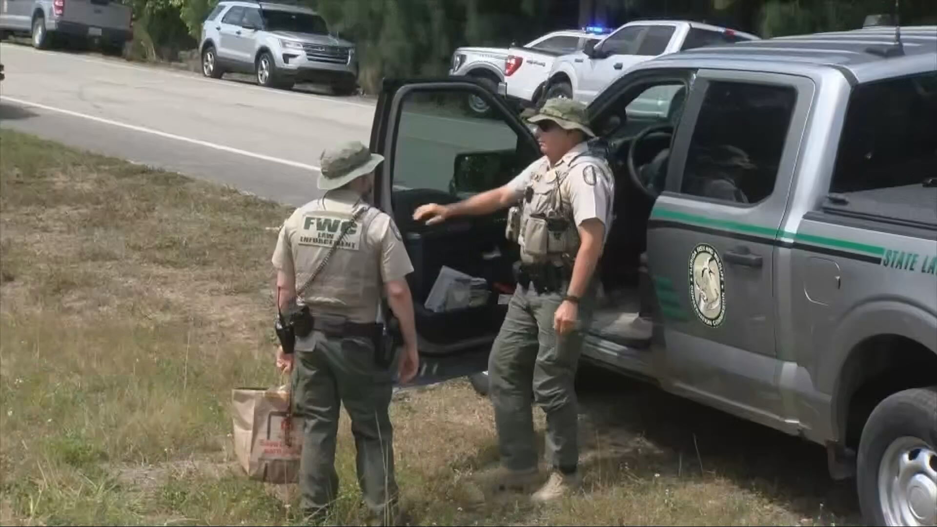
The alarm was raised shortly after 7 a.m. Monday when authorities were alerted to the scene near Jerome. FWC spokesperson George Reynaud confirmed the devastating news: Robert Markel and his dog were deceased. They were found in different locations, but close proximity suggests a single, terrifying event. Officials are treating this as a suspected fatal wildlife attack involving a bear, a scenario that, while rare, is undeniably frightening.

The Search is On

The immediate priority is locating the bear responsible. The FWC and law enforcement are actively searching the area, determined to prevent further incidents. The FWC issued a strong warning, urging residents and visitors to exercise extreme caution and avoid the area. This isn't a time for heroics; approaching or attempting to track wildlife is incredibly dangerous and should be left to the professionals.

Understanding Black Bears in Florida

So, what do we know about black bears in Florida? According to the FWC, black bears are the only bear species found in the state. They are typically shy and avoid human contact, but like any wild animal, they can be unpredictable, especially when they feel threatened or are protecting their young.

Their Natural Habitat

Florida's black bears thrive in a variety of habitats, including forests, swamps, and scrublands. As development encroaches on their territory, encounters with humans become more frequent. This unfortunate incident highlights the growing need for responsible coexistence.

Diet and Behavior

Bears are opportunistic eaters, with a diet consisting primarily of plants, fruits, insects, and occasionally small animals. While attacks on humans are rare, they can occur if a bear feels threatened or if it has become habituated to human food sources. Imagine a bear consistently finding food near homes; it's bound to lose its fear of humans.

Why Bear Attacks Are Rare, But Still Possible

Let's be clear: bear attacks in Florida are relatively uncommon. The FWC works hard to manage the bear population and educate the public on how to avoid conflicts. But "rare" doesn't mean "impossible," as this tragic case demonstrates. What factors contribute to these rare but deadly incidents?

Habitat Loss and Fragmentation

As Florida's population continues to grow, more and more natural habitat is lost to development. This forces bears to venture closer to human settlements in search of food and territory, increasing the likelihood of encounters.

Human-Provided Food Sources

Unfortunately, humans often unintentionally attract bears by leaving out food scraps, unsecure garbage cans, and pet food. When bears associate humans with food, they become less fearful and more likely to approach populated areas.

Accidental Encounters

Sometimes, encounters are simply accidental. A hiker may surprise a bear on a trail, or a homeowner may inadvertently stumble upon a bear in their yard. In these situations, a bear may react defensively, leading to an attack.

Safety Tips: How to Coexist with Bears

The FWC offers several practical tips for minimizing the risk of bear encounters. These aren't just suggestions; they are essential guidelines for living responsibly in bear country. Think of them as your bear-aware survival guide.

Secure Your Garbage

This is perhaps the most important step: use bear-resistant garbage cans or store your garbage in a secure location, such as a garage or shed. Don't let your trash become a bear buffet!

Remove Food Attractants

Take down bird feeders, clean up fallen fruit from trees, and store pet food indoors. Eliminate any potential food sources that could attract bears to your property. Essentially, don't leave anything out that might be considered "room service" for a hungry bear.

Be Aware of Your Surroundings

When hiking or walking in bear country, make noise to avoid surprising a bear. Carry bear spray and know how to use it. Be especially cautious at dawn and dusk, when bears are most active.

Never Approach or Feed a Bear

This should be obvious, but it's worth repeating: never approach or feed a bear. Admire them from a safe distance, and never try to interact with them. Feeding a bear not only puts you in danger, but it also habituates the bear to humans, making it more likely to cause problems in the future.

The Investigation: What Happens Next?

The FWC is conducting a thorough investigation to determine the circumstances of the attack. This includes analyzing the scene, collecting evidence, and attempting to identify the bear involved. If the bear is found, it will likely be euthanized for testing to confirm its involvement in the attack. This is a difficult but necessary step to ensure public safety.

DNA Evidence and Tracking

Investigators will be looking for DNA evidence, such as hair or saliva, to confirm that the bear was indeed responsible for the deaths. They may also use tracking dogs to follow the bear's trail and determine its movements.

Community Response

The local community is understandably shaken by this tragedy. Residents are urged to report any bear sightings to the FWC and to follow safety guidelines to protect themselves and their pets. Community meetings and educational programs may also be organized to address concerns and provide information about bear safety.

The Broader Implications: Living with Wildlife

This incident serves as a stark reminder of the challenges of living in close proximity to wildlife. As our population continues to grow and our cities expand, we must find ways to coexist peacefully with the animals that share our environment. What steps can we take to minimize conflicts and protect both humans and wildlife?

Responsible Development

Careful planning and responsible development are essential. This includes preserving natural habitats, creating wildlife corridors, and implementing regulations to minimize human-wildlife interactions. Can you imagine if urban planners considered wildlife needs as importantly as building codes?

Education and Outreach

Public education is crucial. People need to understand the risks of living in bear country and how to take steps to protect themselves and their property. The FWC and other organizations can play a vital role in providing information and resources to the public.

Population Management

In some cases, population management may be necessary to control bear numbers and reduce the risk of conflicts. This could include relocation or, in extreme cases, culling. However, these measures should be carefully considered and implemented only as a last resort.

A Time for Reflection and Caution

This tragedy is a somber reminder that we share our world with powerful and potentially dangerous animals. While bear attacks are rare, they can happen, and we must take precautions to protect ourselves and our communities. Remember, respecting wildlife is not just about protecting animals; it's about protecting ourselves as well.

Conclusion: Key Takeaways

The suspected bear attack that claimed the lives of Robert Markel and his dog is a devastating event. It underscores the importance of understanding and respecting wildlife, especially in areas where human and animal habitats overlap. Securing garbage, removing food attractants, and being aware of your surroundings are crucial steps in minimizing the risk of bear encounters. The FWC is actively investigating the incident and taking measures to ensure public safety. As we mourn this loss, let us also recommit to responsible coexistence with the wildlife that shares our state.

Frequently Asked Questions (FAQs)

  1. How common are bear attacks in Florida?

    Bear attacks in Florida are rare. While black bears are present throughout the state, they generally avoid human contact. Most incidents are related to bears seeking food and are preventable with proper precautions.

  2. What should I do if I encounter a bear?

    If you see a bear, remain calm and give it space. Do not approach it or try to feed it. If the bear approaches you, make yourself look large and make noise. If attacked, fight back using anything available as a weapon.

  3. Are some areas of Florida more prone to bear attacks than others?

    Areas with significant natural habitats, such as forests and swamps, are more likely to have bear populations. Development near these areas increases the potential for human-bear encounters. Check with local authorities for specific information about bear activity in your region.

  4. What is the FWC doing to prevent future bear attacks?

    The FWC actively manages the bear population through habitat conservation, public education programs, and research. They also respond to reports of bear sightings and conflicts, providing guidance and assistance to residents.

  5. How can I make my home and property less attractive to bears?

    The best way to deter bears is to remove potential food sources. Secure garbage cans, store pet food indoors, clean up fallen fruit, and take down bird feeders. Consider installing motion-activated lights and fencing to further discourage bears from approaching your property.

Flash Flood Alert: NYC & Tri-State Braces for Heavy Rain!

Flash Flood Alert: NYC & Tri-State Braces for Heavy Rain!

Flash Flood Alert: NYC & Tri-State Braces for Heavy Rain!

New York Under the Rain: Flash Flood Watch as Heavy Rain Arrives!

Heads Up, Tri-State! Get Ready for a Wet Weekend

Alright New Yorkers, Mother Nature is at it again! We're expecting a deluge of rain to soak the tri-state area starting Thursday afternoon and lingering into Saturday. Think of it as Mother Nature's early tears of joy (or perhaps frustration with our collective weather complaints). This could mean a soggy end to the work week and potential flash flooding. But don't despair! There's a silver lining – the skies are expected to clear just in time for a gorgeous Mother's Day!

Thursday's Damp Start: The Pre-Weekend Drizzle

Remember that umbrella you swore you'd never forget again? Well, dig it out! Scattered showers are predicted to pop up by mid-afternoon on Thursday. These showers are expected to grow in intensity and coverage as the day progresses, meaning your evening commute could be a bit of a soggy mess, especially if you're north or west of the I-95 corridor. Consider yourself warned: plan accordingly! Think about it: is working from home an option? Maybe leave the office a tad early? It's always better to be prepared than to be caught in the rain!

Friday's Downpour: Get Ready for a Soaking

Hold on to your hats, folks! Thursday was just a warm-up. The real show starts overnight and continues into Friday morning. We're talking moderate to heavy rain possible throughout the entire day. Expect conditions to be consistently wet, with the heaviest rainfall predicted during the morning hours.

Rainfall Totals: How Much Can We Expect?

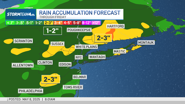
So, how much rain are we actually talking about? Experts predict total rainfall amounts of up to 2 inches across the region. But here's the kicker: some areas could see locally higher amounts. Translation: your particular neighborhood could get hit even harder. We're talking the potential for localized flooding, so keep a close eye on those low-lying areas!


Understanding Flash Flood Potential

Let’s talk about the elephant in the room: flash floods. What causes them, and why are we potentially at risk? Flash floods occur when rainfall exceeds the land's ability to absorb it, leading to rapid runoff. Considering the recent rainfall in some areas and the expected heavy downpours, the ground is already saturated. This increases the risk of flash flooding dramatically.

Factors Contributing to Flash Floods

  • Saturated Ground: The ground can't soak up any more water!
  • Heavy Rainfall Rates: Intense downpours overwhelm drainage systems.
  • Urban Areas: Pavement and concrete prevent water absorption.
  • Steep Terrain: Water flows downhill quickly, gathering momentum.

Interactive Radar: Your Weather Wingman

(Assume that the Javascript code for the interactive radar would be placed here).

Commuting Considerations: Navigating the Soggy Streets

Okay, let's get practical. How will this rain affect your commute? Public transportation could experience delays due to flooded tracks or signal issues. Road travel will be treacherous, with reduced visibility and hydroplaning risks. Bottom line: give yourself extra travel time and drive with extreme caution!

Safety Tips for Driving in Heavy Rain

  1. Slow Down: Reduce your speed significantly.
  2. Increase Following Distance: Give yourself more space to react.
  3. Turn on Headlights: Even during the day, headlights improve visibility.
  4. Avoid Standing Water: Hydroplaning is a real danger!
  5. Never Drive Through Flooded Roads: Turn around, don't drown!

Home Preparation: Protecting Your Property

Don't just think about the commute; think about your home! Take some proactive steps to minimize potential damage from the rain.

Protecting Your Home from Flooding

  • Clear Gutters and Downspouts: Ensure rainwater can flow freely away from your home.
  • Move Valuables: Raise valuable items off the floor in basements.
  • Check Sump Pumps: Ensure your sump pump is working correctly.
  • Seal Windows and Doors: Prevent water from seeping into your home.

Mother's Day Forecast: Sunshine and Smiles!

Now for the good news! While Friday might be a washout, the forecast for Mother's Day is looking spectacular. Expect sunshine, clear skies, and pleasant temperatures. Perfect weather to celebrate the amazing moms in our lives! So, plan that picnic, brunch, or outdoor activity – Mom deserves it!

Staying Informed: Your Weather Resources

It's crucial to stay updated on the latest weather forecasts and warnings. Here are some resources to keep you informed:

Reliable Weather Information Sources

  • Local News Channels: Check your local news for up-to-the-minute updates.
  • National Weather Service: The official source for weather information.
  • Weather Apps: Use reliable weather apps on your smartphone.
  • Emergency Alerts: Sign up for emergency alerts from your local government.

The Bigger Picture: Climate Change and Extreme Weather

While this specific weather event is just that – a weather event – it's important to consider the broader context of climate change. Are we seeing more frequent and intense rainfall events? Many scientists believe that climate change is contributing to more extreme weather patterns around the globe. Understanding the science behind climate change is crucial for preparing for the future.

Community Preparedness: Neighbors Helping Neighbors

During times of severe weather, it's essential to look out for your neighbors. Check in on elderly residents or those with disabilities. A little bit of kindness can go a long way in ensuring everyone's safety.

Flood Insurance: Is It Worth It?

Have you considered flood insurance? Standard homeowner's insurance policies typically don't cover flood damage. If you live in an area prone to flooding, flood insurance is definitely something to think about. It can provide crucial financial protection in the event of a flood.

Beyond the Rain: Dealing with Post-Storm Cleanup

Once the rain stops, the cleanup begins. Be cautious of downed power lines, standing water, and debris. Wear protective gear like gloves and boots when handling floodwater, as it can be contaminated. Safety should always be your top priority during the cleanup process.

Conclusion: Stay Safe and Prepared!

So, there you have it, New York! Heavy rain is on its way, potentially leading to flash floods. Stay informed, be prepared, and drive safely. Remember, this too shall pass, and beautiful Mother's Day weather is right around the corner! The key takeaways are: expect heavy rain, prepare for possible flooding, stay informed through trusted sources, and be cautious during commutes. But most importantly, stay safe and look out for each other!

Frequently Asked Questions

  1. What is the difference between a flash flood watch and a flash flood warning?

    A flash flood watch means that conditions are favorable for flash flooding to occur. A flash flood warning means that flash flooding is imminent or is already occurring. Take action immediately if a flash flood warning is issued for your area.

  2. How can I find out if my area is prone to flooding?

    Check with your local government or emergency management agency. They can provide flood zone maps and information about flood risks in your area.

  3. What should I do if I'm caught in a flash flood while driving?

    The safest thing to do is to abandon your vehicle and seek higher ground. However, if you are unable to safely exit the vehicle, stay inside and call for help. Never drive through flooded roads, as even shallow water can sweep your car away.

  4. How can I protect my car from flood damage?

    If possible, move your car to higher ground before the flooding begins. If you can't move your car, try to park it in a location that is less likely to flood, such as a parking garage or a high spot in a parking lot.

  5. Where can I get sandbags to protect my home from flooding?

    Contact your local government or emergency management agency. They may provide sandbags to residents in flood-prone areas. You can also purchase sandbags at hardware stores.

New York Flash Flooding: Stay Safe Friday!

New York Flash Flooding: Stay Safe Friday!

New York Flash Flooding: Stay Safe Friday!

New York Braces for All-Day Washout: Flash Flood Watch Issued!

Introduction: From Sunlight to Soaking Friday

Remember that brief, glorious glimpse of sunshine we had on Wednesday? Ah, good times. But as the old saying goes, all good things must come to an end. And unfortunately, the end of that sunshine spell is rapidly approaching. After a few damp and dreary days, we're looking at a significantly wetter forecast, especially for Friday. Get ready, New York area, because it's shaping up to be an all-day washout with the potential for flash flooding. Are you prepared?

Thursday's Teaser: Scattered Showers on the Horizon

Don't put away your umbrellas just yet. Thursday is bringing us a preview of the weekend weather, with scattered showers expected throughout the afternoon. North Jersey and the Hudson Valley are likely to see the brunt of this pre-Friday dampness.

North Jersey and the Hudson Valley: Early Showers

If you're traveling in North Jersey or the Hudson Valley this afternoon, be prepared for wet conditions. These areas will likely see the earliest showers, making the afternoon commute a bit more challenging.

Coastal Areas: A Drier Start

For those closer to the coast, you might get away with a relatively dry Thursday until later in the evening. Enjoy it while it lasts, because Friday's forecast is a whole different story.

Friday's Flood Threat: A Deep Dive into the Downpour

Now, let's talk about Friday. This isn't just a little drizzle; we're talking about a significant weather event that could bring considerable rainfall and potentially dangerous flash flooding. Friday is the day to stay informed and prepared.

The Setup: Why Friday Will Be So Wet

A slow-moving weather system is expected to stall over the New York area on Friday, bringing with it a prolonged period of heavy rain. Think of it like a leaky faucet, but instead of a few drops, it's a torrential downpour lasting all day. This prolonged rainfall is what raises the risk of flash flooding.

Rainfall Estimates: How Much is Too Much?

Current forecasts suggest that many areas could see several inches of rain on Friday. While the exact amount will vary depending on location, even a few inches of rain falling in a short period can overwhelm drainage systems and lead to flooding.

Flash Flood Watch: What Does it Mean?

A flash flood watch means that conditions are favorable for flash flooding to occur in and close to the watch area. It's a heads-up that you need to be aware of the potential dangers and prepared to take action. It's not a guarantee of flooding, but it's a serious warning.

Potential Impacts: What to Expect

The all-day washout on Friday could have a significant impact on daily life in the New York area. Here are some of the things you should be prepared for:

Travel Disruptions: Prepare for Delays

Heavy rain can significantly reduce visibility and make driving conditions hazardous. Expect delays on roads and public transportation. If possible, consider working from home or postponing non-essential travel.

Localized Flooding: Know Your Risks

Low-lying areas, urban streets with poor drainage, and areas near streams and rivers are particularly vulnerable to flash flooding. Know your neighborhood's flood risk and have a plan in place in case flooding occurs.

Power Outages: Stay Connected

Heavy rain and strong winds can sometimes lead to power outages. Make sure your devices are charged, and have flashlights and batteries on hand. It's also a good idea to download important documents and contacts to your phone in case you lose power.

Staying Safe: Tips for Navigating the Washout

Your safety is paramount. Here are some essential tips for staying safe during Friday's all-day washout:

Never Drive Through Floodwater: Turn Around, Don't Drown

This is the golden rule of flash flood safety. Never, ever drive through floodwater. The water may be deeper than it appears, and your car could easily be swept away. It only takes a few inches of moving water to lose control of a vehicle. If you encounter floodwater, turn around and find an alternate route.

Stay Informed: Monitor Weather Updates

Keep an eye on the latest weather forecasts and alerts from reliable sources such as the National Weather Service and local news outlets. Conditions can change rapidly, so it's essential to stay informed.

Secure Your Property: Take Preventative Measures

If you live in an area prone to flooding, take steps to protect your property. Clear gutters and downspouts, move valuables to higher ground, and consider sandbagging vulnerable areas.

Beyond Friday: What's Next?

While Friday's washout is the main concern right now, it's important to look ahead and see what the weekend holds.

Saturday's Forecast: Clearing Skies?

Early indications suggest that the rain will begin to taper off by Saturday, with the potential for clearing skies later in the day. However, keep in mind that forecasts can change, so stay tuned for updates.

Long-Term Outlook: A Return to Normal?

Looking further ahead, the long-term outlook suggests a return to more typical weather patterns for this time of year. Hopefully, that means more sunshine and fewer rainy days in the forecast.

Preparing Your Home: Flood Preparedness Checklist

Being prepared for a flood doesn't have to be overwhelming. Here's a simple checklist to get you started:

  • Check your insurance coverage: Make sure you have adequate flood insurance if you live in a flood-prone area.
  • Create an emergency kit: Include water, food, medication, a flashlight, and a first-aid kit.
  • Know your evacuation routes: Familiarize yourself with the designated evacuation routes in your area.
  • Elevate valuables: Move important documents and valuables to higher floors or storage areas.
  • Trim trees and shrubs: Prevent damage from falling branches during heavy winds.

Community Resources: Where to Find Help

In times of severe weather, knowing where to turn for help is crucial. Here are some community resources that can provide assistance:

  • Local Emergency Management Agencies: These agencies coordinate emergency response efforts in your area.
  • American Red Cross: The Red Cross provides shelter, food, and other assistance to those affected by disasters.
  • United Way: United Way connects people with resources and services in their community.
  • Local News Outlets: Stay informed about emergency information and updates through local news channels.

The Psychological Impact: Staying Positive During a Washout

Let's be honest: being stuck inside all day during a washout can be a real downer. But don't let the weather get you down! Here are some tips for staying positive:

Embrace Indoor Activities: Find Rainy-Day Fun

Use the time to catch up on reading, watch movies, play board games, or pursue other indoor hobbies. Think of it as a forced day of relaxation and recharge.

Connect with Loved Ones: Stay Social, Even Indoors

Reach out to friends and family via phone, video call, or social media. Staying connected can help you feel less isolated and more positive.

Practice Self-Care: Prioritize Your Well-being

Take some time for self-care activities such as taking a warm bath, listening to music, or practicing mindfulness. Remember to prioritize your mental and emotional health during stressful times.

Conclusion: Staying Safe and Informed During the Storm

As we brace for Friday's all-day washout and the potential for flash flooding, remember the key takeaways: Stay informed, stay safe, and never drive through floodwater. Monitor weather updates, prepare your home, and know where to find help if you need it. While a day of heavy rain may disrupt our plans, by taking the necessary precautions, we can weather the storm and come out stronger on the other side.

Frequently Asked Questions (FAQs)

  1. What is the difference between a flash flood watch and a flash flood warning?

    A flash flood watch means that conditions are favorable for flash flooding to occur. A flash flood warning means that flash flooding is already occurring or is imminent.

  2. How can I prepare my home for a potential flood?

    Clear gutters and downspouts, move valuables to higher ground, consider sandbagging vulnerable areas, and ensure you have adequate flood insurance.

  3. What should I do if I encounter floodwater while driving?

    Turn around and find an alternate route. Never drive through floodwater, as it only takes a few inches of moving water to lose control of a vehicle.

  4. Where can I find reliable information about weather updates and alerts?

    The National Weather Service and local news outlets are reliable sources for weather updates and alerts. You can also download weather apps to your phone for real-time information.

  5. What resources are available to help those affected by flooding?

    Local Emergency Management Agencies, the American Red Cross, and United Way are all resources that can provide assistance to those affected by flooding.

Flash Flood Watch: 2 Inches of Rain Threatens NY Area

Flash Flood Watch: 2 Inches of Rain Threatens NY Area

Flash Flood Watch: 2 Inches of Rain Threatens NY Area

New York Under Threat: Flash Flood Warning as Up to 2 Inches of Rain Expected

Get Ready for a Soggy Friday: Rain Alert Issued for NY Area

Are you ready for a wet one, New York? It looks like Friday is going to be a soaker! Up to 2 inches of rain are expected to drench the New York metropolitan area, and that's not just a drizzle. We're talking about a potential day-long washout that could lead to some serious problems.

The Threat of Flash Flooding: Don't Underestimate the Power of Rain

While the sound of rain might be relaxing, the reality is that this much precipitation in a short period can be dangerous. The big concern is flash flooding, especially in areas already vulnerable. Think about low-lying streets, poor drainage systems, and areas near rivers – these are the places where you need to be extra cautious.

What is Flash Flooding Anyway?

Flash flooding is basically what it sounds like: a flood that happens incredibly quickly. Unlike river flooding, which develops over days, flash floods can occur within minutes or hours of intense rainfall. This speed makes them particularly dangerous because there's often little time to react. It's like a surprise attack from Mother Nature!

Why is This Time More Risky?

Good question! River levels have already been on the rise this week, meaning that the ground is saturated and there's less capacity for the water to go. It's like filling a glass that's already almost full; it doesn't take much to make it overflow. Even a relatively small amount of additional rain could push rivers over their banks and cause widespread flooding.

Which Areas Are Under Flood Watch?

It's not just New York City feeling the pressure. Flood watches are in effect for a wide range of locations, including:

  • Fairfield County in Connecticut
  • Parts of Northern New Jersey
  • Long Island
  • The Hudson Valley

It's crucial to pay attention to local alerts in your specific neighborhood, as conditions can vary greatly from one town to the next. Don't assume you're safe just because you're a few miles away from an area under watch.

Stay Informed: Your Essential Weather Resources

The weather is a dynamic beast, constantly changing, so the best way to stay safe is to stay informed. Bookmark reliable weather websites and apps, and check them frequently throughout the day.

Official Weather Alerts

Always rely on official sources for weather alerts. The National Weather Service (NWS) is your go-to for accurate and timely information. Their website and app provide up-to-the-minute warnings, watches, and advisories.

Interactive Radar: Track the Storm's Progress

Being able to visualize the storm's progress is incredibly helpful. Interactive radar maps allow you to see where the heaviest rain is falling, how quickly it's moving, and whether it's intensifying or weakening. It's like having a personal weather forecaster at your fingertips.

Preparing for the Storm: Essential Safety Tips

Don't wait until the rain starts pouring to think about safety. Take these precautions now to minimize your risk.

Avoid Low-Lying Areas: Don't Drive Through Floodwaters

This is the golden rule of flash flood safety: never drive through floodwaters. It might look shallow, but even a few inches of rapidly moving water can sweep away a car. Turn around, don't drown! It's a simple phrase, but it could save your life.

Secure Your Property: Protect Your Belongings

If you live in an area prone to flooding, take steps to protect your property. Move valuables to higher ground, clear gutters and downspouts to ensure proper drainage, and consider sandbagging vulnerable areas around your home.

Have an Emergency Plan: Know What to Do

Discuss an emergency plan with your family. Where will you meet if you get separated? What supplies do you need? How will you communicate if cell service is down? Having a plan in place can reduce panic and help you respond effectively in a crisis.

Prepare an Emergency Kit: Essentials You Can't Live Without

An emergency kit is your lifeline during a disaster. Include essentials like:

  • Bottled water
  • Non-perishable food
  • A first-aid kit
  • A flashlight
  • A battery-powered radio
  • Extra batteries

Navigating the City During the Storm: Commuting Challenges

Friday's commute could be a nightmare. Expect delays and disruptions on public transportation, and be prepared for road closures and traffic congestion. If possible, consider working from home or adjusting your travel schedule to avoid the worst of the storm.

Public Transportation: Expect Delays and Closures

Subways and buses are vulnerable to flooding, especially in low-lying areas. Monitor MTA alerts for service changes and be prepared for potential delays or suspensions. Consider alternative routes or modes of transportation if possible.

Driving Conditions: Exercise Extreme Caution

If you must drive, exercise extreme caution. Reduce your speed, increase your following distance, and be extra vigilant for pedestrians and cyclists. Remember, stopping distances increase dramatically in wet weather.

Beyond Friday: Long-Term Flood Preparedness

While this particular storm will eventually pass, the threat of flooding is a constant reality in many parts of the New York area. Taking steps to prepare for future events is essential.

Flood Insurance: Is It Worth It?

Many homeowners are surprised to learn that standard homeowners insurance doesn't cover flood damage. Flood insurance is a separate policy that can protect your home and belongings from the devastating effects of flooding. Even if you don't live in a designated flood zone, it's worth considering.

Community Resilience: Working Together

Building community resilience is crucial for long-term flood preparedness. Get involved in local initiatives to improve drainage systems, raise awareness about flood risks, and support vulnerable populations. We're all in this together!

Conclusion: Stay Safe, Stay Informed, Stay Prepared

Friday's rain event poses a significant threat of flash flooding in the New York area. Remember, up to 2 inches of rain is expected, and river levels are already high. Pay attention to local weather alerts, avoid low-lying areas, and never drive through floodwaters. Stay informed, stay prepared, and stay safe!

Frequently Asked Questions (FAQs) About Flash Flooding

  1. What is the difference between a flood watch and a flood warning?
    A flood watch means that conditions are favorable for flooding to occur. A flood warning means that flooding is already occurring or is imminent. Treat a flood warning as a serious emergency and take immediate action to protect yourself and your property.
  2. How much water does it take to sweep away a car?
    Believe it or not, as little as 6 inches of fast-moving water can knock an adult off their feet, and just 12 inches can sweep away a car. Two feet of rushing water can carry away most vehicles, including SUVs and trucks.
  3. What should I do if my car gets stuck in floodwaters?
    If possible, abandon your car and move to higher ground. If you cannot safely exit the vehicle, call 911 for help. Do not try to start the engine, as this could damage the electrical system and make the situation worse.
  4. How can I find out if I live in a flood zone?
    You can check your flood zone status on the FEMA Flood Map Service Center website. You can also contact your local floodplain manager or insurance agent for assistance.
  5. What steps can I take to reduce my risk of flood damage in the future?
    Consider raising your home's foundation, installing flood vents, and improving drainage around your property. You can also landscape with flood-resistant plants and seal basement walls to prevent water from seeping in. Always prioritize flood insurance to protect your finances.
Home Explosion in NJ: 2 Dead, Investigation Begins

Home Explosion in NJ: 2 Dead, Investigation Begins

Home Explosion in NJ: 2 Dead, Investigation Begins

Washington Twp. Tragedy: Home 'Explodes,' Claiming Two Lives

Introduction: A Community Shaken

A quiet Sunday morning in Washington Township, New Jersey, was shattered as news spread like wildfire: a home had exploded overnight, leaving behind a scene of devastation and, tragically, the remains of two lives. The intersection of Orion Way and Tranquility Court, usually a picture of suburban peace, became a focal point of emergency response and community grief. We'll delve into what we know so far, piecing together the details of this heartbreaking event.

The Overnight Inferno: What Happened?

Initial Reports and Response

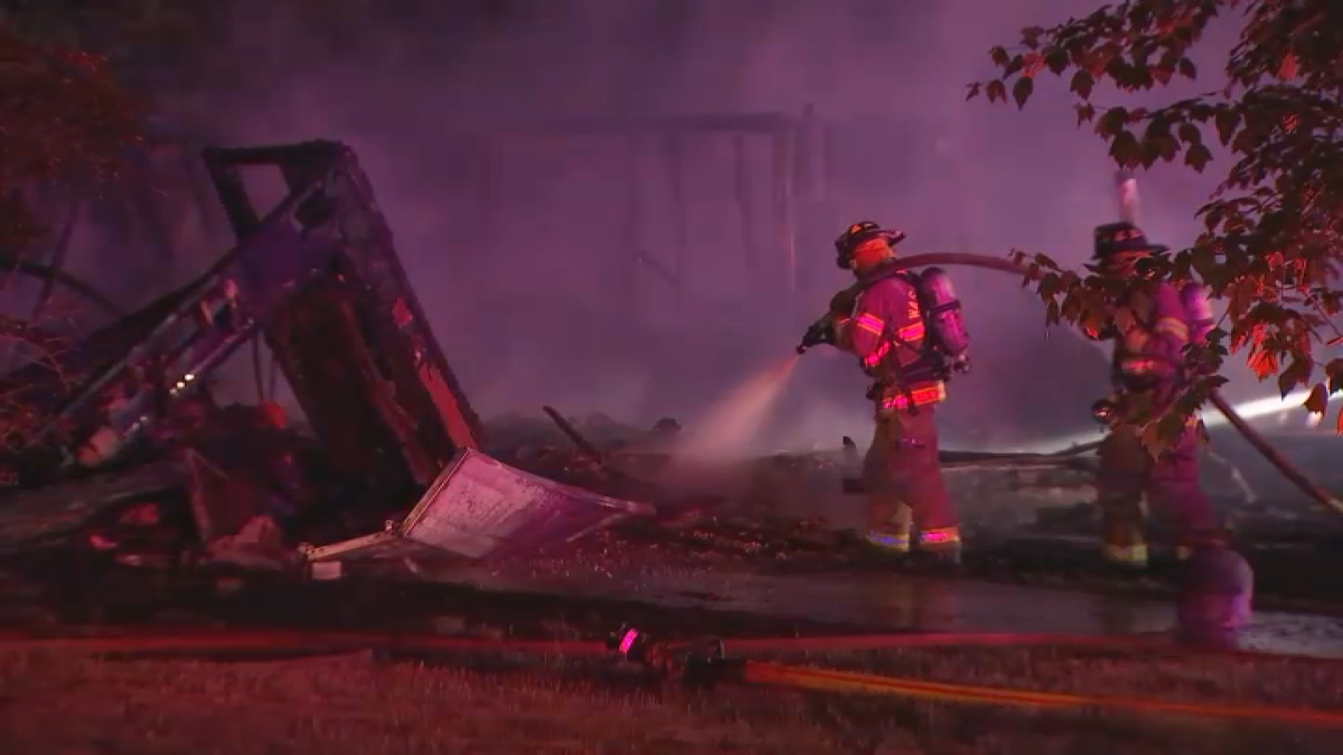
According to initial reports, the incident occurred at approximately 2 a.m. on Sunday. Neighbors reported hearing a loud explosion, followed by flames engulfing a residence. Fire crews swiftly responded to the scene, battling the blaze amidst the debris. But the worst was yet to come. Two body bags were removed from the scene later that morning, confirming the worst fears: lives had been lost.

Surveillance Footage: A Glimpse of Horror

NBC10 has obtained surveillance footage capturing the moment the home erupted in flames. While the details of the footage haven't been fully released, it paints a stark picture of the sudden and violent nature of the incident. Can you imagine witnessing something so sudden and destructive? It's a chilling reminder of the fragility of life and the potential for unexpected tragedy.

The Victims: A Community Mourns

Confirmed Deaths: Man and Woman

Officials have confirmed that the two bodies recovered from the home were those of a man and a woman. However, at the time of this report, further identifying information has not been released pending notification of next of kin. Our thoughts are with their families and loved ones during this incredibly difficult time. We can only imagine the depth of their sorrow.

Identifying Information: Awaiting Confirmation

The authorities are working diligently to identify the victims and provide closure to their families. This process often takes time, as investigators meticulously gather evidence and ensure accurate identification. We'll continue to update this story as more information becomes available. Patience and respect for the grieving families are paramount at this time.

The Investigation: Unraveling the Mystery

Cause of the 'Explosion': What We Know

The term "explosion" suggests a rapid and forceful event. However, the exact cause of the incident is still under investigation. Was it a gas leak? A malfunction of some kind? Arson? These are the questions investigators are working to answer. Until the investigation is complete, it's important to avoid speculation and allow the authorities to do their job.

Potential Causes: Exploring the Possibilities

Several factors could potentially contribute to a house explosion. These include:

  • Natural gas leaks: Even small leaks can accumulate and ignite, causing a devastating explosion.
  • Propane leaks: Similar to natural gas, propane is highly flammable and can pose a significant risk.
  • Faulty appliances: Malfunctioning appliances, such as stoves or water heaters, can lead to gas leaks or electrical fires.
  • Chemical reactions: In rare cases, incompatible chemicals stored improperly can react and cause an explosion.
  • Structural issues: While less common, structural damage to a building can weaken gas lines and increase the risk of leaks.

The Role of Investigators: Seeking Answers

A team of investigators is on the scene, meticulously combing through the debris for clues. They're collecting evidence, interviewing witnesses, and working to reconstruct the events leading up to the explosion. Their goal is to determine the exact cause of the incident and prevent similar tragedies from happening in the future. It's a complex and painstaking process, but their efforts are crucial.

The Aftermath: Community Response and Recovery

Impact on the Neighborhood: A Scene of Devastation

The explosion has undoubtedly had a significant impact on the surrounding neighborhood. The scene is described as one of widespread debris, a stark reminder of the destructive power of the incident. Neighbors are understandably shaken and concerned about their own safety. The sense of community is tested during times like these.

Community Support: Coming Together in Grief

In the face of tragedy, communities often come together to support one another. Neighbors are offering assistance to those affected, providing comfort and practical help. Local organizations are also stepping up to provide resources and support services. It's a testament to the resilience and compassion of the human spirit. How can we help our neighbors in their time of need?

Safety Precautions: Protecting Your Home

While the cause of the Washington Township explosion remains under investigation, it's a good time to review safety precautions to protect your home. Here are some tips:

  • Install and maintain smoke detectors: Test them regularly and replace batteries as needed.
  • Install carbon monoxide detectors: Carbon monoxide is a silent killer, so detectors are essential.
  • Have your gas appliances inspected annually: A professional can identify potential problems before they become dangerous.
  • Be aware of gas odors: If you smell gas, evacuate immediately and call your gas company.
  • Store flammable materials properly: Keep them away from heat sources and ensure adequate ventilation.

Remembering the Victims: Honoring Their Memory

Memorial Services: A Time for Remembrance

As the community mourns, memorial services will likely be held to honor the lives of the victims. These services will provide an opportunity for friends, family, and neighbors to come together and remember those who were lost. It's a time for shared grief and collective healing. How can we best honor the memory of those who are gone?

Supporting the Grieving Families: Offering Condolences

The families of the victims are facing unimaginable pain. It's important to offer them our condolences and support during this difficult time. A simple act of kindness, such as sending a card or offering a listening ear, can make a world of difference. Let's remember to be compassionate and understanding as they navigate their grief.

Ongoing Updates: Staying Informed

The Latest Developments: Follow the Investigation

This is a developing story, and we will continue to provide updates as more information becomes available. Check back regularly for the latest developments in the investigation. We are committed to keeping you informed and providing accurate information.

Where to Find More Information: Trusted Sources

For the most up-to-date and accurate information, rely on trusted news sources such as NBC10 and official statements from local authorities. Be wary of social media rumors and misinformation. It's crucial to stay informed from reliable sources during times of crisis.

Understanding Explosions: The Science Behind the Devastation

The Chemistry of an Explosion: A Chain Reaction

An explosion, at its core, is a rapid release of energy that creates a large volume of gas in a very short period. This rapid expansion of gas produces a powerful shockwave. Think of it like popping a balloon, but on a much larger and more destructive scale. The key is a chain reaction that amplifies the initial energy release.

Types of Explosions: Deflagration vs. Detonation

There are different types of explosions, primarily categorized as deflagrations and detonations. Deflagrations involve subsonic combustion (slower than the speed of sound), while detonations involve supersonic combustion. Detonations are much more powerful and destructive. In simple terms, a detonation is like a supercharged deflagration.

Gas Safety: Protecting Your Home and Family

Recognizing Gas Leaks: Warning Signs to Watch For

Natural gas and propane are naturally odorless, so gas companies add a chemical called mercaptan to give them a distinct "rotten egg" smell. This is a crucial safety measure that allows people to detect gas leaks before they become dangerous. If you smell gas, don't hesitate – act immediately!

What to Do in Case of a Gas Leak: Prioritizing Safety

If you suspect a gas leak, follow these steps:

  1. Evacuate immediately: Get everyone out of the building as quickly as possible.
  2. Do not use any electrical switches or devices: These could create a spark and ignite the gas.
  3. Do not use your phone inside the building: Move to a safe location before calling for help.
  4. Call your gas company or 911: Report the leak and follow their instructions.
  5. Stay away from the building until it's declared safe: Don't return until authorities give the all-clear.

Home Maintenance: Preventing Future Tragedies

Regular Inspections: A Proactive Approach

Regular home inspections are essential for identifying potential safety hazards. A qualified inspector can check your plumbing, electrical system, and gas appliances for any signs of damage or malfunction. Think of it as a check-up for your house, helping to prevent problems before they escalate.

DIY Maintenance: Simple Steps You Can Take

While professional inspections are important, there are also simple maintenance tasks you can do yourself, such as:

  • Checking smoke and carbon monoxide detectors regularly.
  • Cleaning dryer vents to prevent fires.
  • Inspecting electrical cords for damage.
  • Maintaining your HVAC system.

Conclusion: Lessons Learned and Moving Forward

Conclusion: Reflecting on the Washington Township Tragedy

The tragic explosion in Washington Township serves as a stark reminder of the importance of safety and the fragility of life. Two lives were lost, and a community has been shaken. As investigators work to determine the cause of the incident, we can all take steps to protect our homes and families. Let us remember the victims and offer our support to those affected by this devastating event. May we learn from this tragedy and work together to prevent similar incidents from happening in the future.

Frequently Asked Questions (FAQs)

  1. What caused the explosion in Washington Township?

    The exact cause is still under investigation. Possible causes include gas leaks, faulty appliances, or other factors. Authorities are working to determine the precise cause.

  2. How can I tell if I have a gas leak in my home?

    The most common sign is a distinct "rotten egg" smell. You may also hear a hissing sound near gas appliances. If you suspect a leak, evacuate immediately and call your gas company or 911.

  3. What should I do if I smell gas in my house?

    Evacuate everyone from the building immediately. Do not use any electrical devices or phones inside. Once you're in a safe location, call your gas company or 911.

  4. How often should I have my gas appliances inspected?

    It's recommended to have your gas appliances inspected annually by a qualified professional. This can help identify potential problems before they become dangerous.

  5. Are carbon monoxide detectors as important as smoke detectors?

    Yes, carbon monoxide detectors are equally important. Carbon monoxide is a colorless, odorless gas that can be deadly. Detectors provide an early warning, allowing you to evacuate before it's too late.

Severe Storms This Weekend: What Tri-State Needs to Know

Severe Storms This Weekend: What Tri-State Needs to Know

Severe Storms This Weekend: What Tri-State Needs to Know

Weekend Weather Alert: Isolated Strong-to-Severe Storms Threaten Your Friday and Saturday

Introduction: Bracing for Another Round of Storms

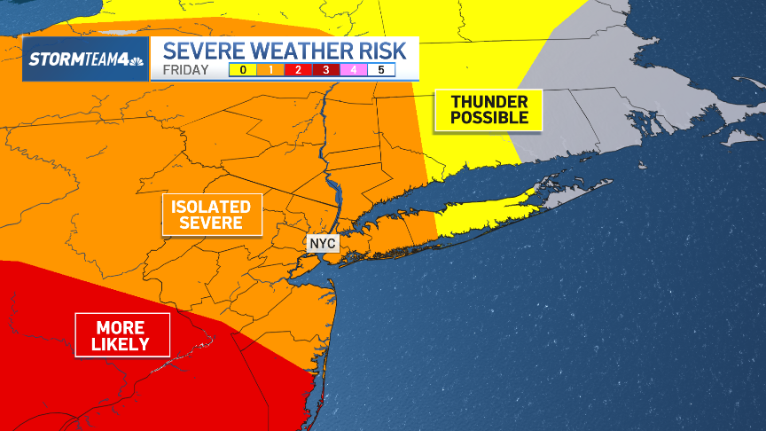
Remember that feeling of finally packing away the umbrellas, only to realize you need them again the next day? Well, here we go again! For the second week running, we've been navigating cloudy skies and the accompanying rain. While Wednesday bore the brunt of this week's rainfall, the weather isn't quite done with us yet. We're keeping a close eye on the potential for isolated strong-to-severe storms across the tri-state area on both Friday and Saturday. So, what do you need to know to prepare? Let's dive in!

What's Brewing: The Atmospheric Setup

To understand what's going on, let's look at the big picture. The atmosphere is like a giant puzzle, with different pieces – temperature, moisture, and pressure – all interacting. Right now, we've got a few key ingredients coming together that could spell trouble.

Moisture, Instability, and Lift: The Recipe for Storms

Think of these as the key ingredients in a storm recipe. We've got plenty of moisture in the air, providing the fuel for storms to develop. We also have instability, which is like a tightly wound spring – it's the potential energy that allows storms to become strong. And finally, we need a "trigger" – something to lift that moist, unstable air and kick things off. This "lift" can come from things like fronts, upper-level disturbances, or even just the terrain.

Timing is Everything: When to Expect the Storms

So, when exactly should you be on alert? Here's a breakdown of the expected timeline:

Friday's Forecast: Isolated Afternoon and Evening Threat

Friday's primary threat window will be in the afternoon and evening hours. As the sun heats the ground, the atmosphere will become even more unstable, increasing the chances of storm development. The exact timing and location of these storms are still somewhat uncertain, but it's best to be prepared.

Saturday's Outlook: Similar Pattern, Slightly Higher Potential

Saturday looks like a repeat of Friday, with a similar atmospheric setup. However, some models suggest that the overall potential for strong-to-severe storms could be slightly higher on Saturday. Keep in mind that the forecast can change, so it’s wise to check the forecast before you leave home.

The Risks: What Kind of Weather to Expect

What exactly do we mean by "strong-to-severe" storms? Here's what to watch out for:

Damaging Winds: A Widespread Threat

Damaging winds are likely to be the primary threat with these storms. Think of it like this: imagine someone swinging a baseball bat through the air. Strong winds can do significant damage, knocking down trees, power lines, and causing structural damage.

Large Hail: An Icy Assault

Large hail is another possibility. Hailstones can range in size from small peas to golf balls (or even larger!), and they can cause significant damage to cars, roofs, and crops. Imagine being bombarded by icy projectiles falling from the sky.

Heavy Rain: Potential for Flash Flooding

Heavy rainfall is also a concern. If storms linger over the same area for an extended period, it could lead to flash flooding. This is especially true in urban areas where drainage systems can be overwhelmed. It is always important to avoid flood water on the roads.

Isolated Tornadoes: A Low, But Non-Zero, Risk

While the overall risk of tornadoes is relatively low, it's not zero. Tornadoes are localized, intense columns of rotating air that can cause catastrophic damage. Stay informed and know what to do if a tornado warning is issued.

Staying Safe: Your Action Plan

Now that you know the risks, let's talk about how to stay safe.

Staying Informed: Monitor Weather Updates

The most important thing you can do is stay informed. Monitor local weather forecasts from reliable sources like the National Weather Service or your local news. Pay attention to any watches or warnings that are issued.

Have a Plan: Prepare for Potential Power Outages

Power outages are a common occurrence during severe storms. Make sure you have a flashlight, battery-powered radio, and extra batteries on hand. Consider investing in a generator if you rely on electricity for medical equipment or other essential needs.

Seek Shelter: Know Where to Go

If a severe thunderstorm warning is issued for your area, seek shelter immediately. The safest place to be is indoors, in a sturdy building, away from windows. If you live in a mobile home, find a designated shelter or a sturdy building nearby.

Driving Precautions: Avoid Flooded Areas

Never drive through flooded areas. The water may be deeper than it appears, and even a few inches of moving water can sweep away a car. Turn around, don’t drown!

Long-Term Preparedness: Being Ready for Anything

Beyond the immediate threat of this weekend's storms, it's a good idea to have a general emergency preparedness plan in place.

Emergency Kit: Stock Up on Essentials

Assemble an emergency kit with enough supplies to last for at least three days. Include things like food, water, first-aid supplies, medications, and personal hygiene items.

Communication Plan: Stay in Touch with Loved Ones

Have a communication plan so you can stay in touch with family and friends in case of an emergency. Designate a meeting place if you become separated.

The Bigger Picture: Why Are We Seeing More Severe Weather?

It's natural to wonder if there's a reason we seem to be experiencing more frequent and intense weather events. While it's difficult to attribute any single event directly to climate change, scientists agree that a warming climate is likely to lead to more extreme weather in the future.

Climate Change and Severe Weather: The Connection

A warmer atmosphere can hold more moisture, which can fuel stronger storms. Changes in atmospheric patterns can also lead to more frequent and prolonged heat waves, droughts, and heavy rainfall events.

Conclusion: Stay Vigilant and Stay Safe

This weekend, the tri-state area faces the potential for isolated strong-to-severe storms. Remember to stay informed, have a plan, and seek shelter if necessary. The main threats are damaging winds, large hail, heavy rain, and a low risk of tornadoes. While we hope these storms pass without incident, preparation is key to ensuring your safety. Stay vigilant, and stay safe!

Frequently Asked Questions (FAQs)

  1. What's the difference between a severe thunderstorm watch and a severe thunderstorm warning?
    A watch means that conditions are favorable for severe thunderstorms to develop in the area. A warning means that a severe thunderstorm has been sighted or indicated by radar and is imminent in your location.
  2. What should I do if I'm caught outside during a severe thunderstorm?
    Seek shelter immediately in a sturdy building. If no building is available, find a low-lying area away from trees and power lines. Crouch down and cover your head.
  3. How large does hail have to be to be considered severe?
    Hail is classified as severe when it is 1 inch in diameter or larger (about the size of a quarter).
  4. What's the safest place to be in my house during a tornado?
    The safest place is an interior room on the lowest level, away from windows. A basement is ideal. If you don't have a basement, a closet or hallway is a good option.
  5. How can I prepare my home for severe weather?
    Trim trees and shrubs that could fall on your house. Secure loose objects, such as patio furniture. Consider installing storm shutters or reinforcing windows. Have a generator ready in case of power outages.
Isolated Storms: Hot, Humid Saturday - Be Prepared!

Isolated Storms: Hot, Humid Saturday - Be Prepared!

Isolated Storms: Hot, Humid Saturday - Be Prepared!

Hot, Humid Saturday Brings Isolated Severe Storm Threat

Introduction: A Muggy End to an Unsettled Week

Well, folks, it's been one of those weeks, hasn't it? A real rollercoaster of sunshine, spring showers, and that unmistakable feeling of humidity creeping back into the air. Just when you thought you could put away the umbrella for good, BAM! Another downpour. And guess what? Mother Nature isn't quite done with us yet.

A flurry of muggy, stormy weather caps off an unsettled week filled with our fair share of spring showers.

The heat and humidity has been cranked up to end the week, but if you can make it through Saturday, relief is on the way.

Saturday's Forecast: Hot, Humid, and Potentially Stormy

Let's break down what Saturday has in store. The first half of the weekend looks to stay a bit more dry. Many in the tri-state can expect to face a mostly dry Saturday, albeit a hot one. But don't let that fool you – the atmosphere is primed for action. We're talking heat, humidity, and just the right amount of instability to potentially trigger some isolated storms.

Morning Sunshine, Afternoon Uncertainty

Imagine waking up to sunshine, maybe even planning a picnic or a trip to the park. Sounds lovely, right? And it might be! But keep an eye on the sky. An isolated storm could roll through the region at any time from late morning through the evening.

The Severity Threat: What to Watch For

Now, when we say "potentially severe," what does that actually mean? It means we're not just talking about a little rain and thunder. We're talking about the possibility of:

  • Damaging Winds: Think gusts strong enough to knock down tree branches and power lines.
  • Large Hail: Imagine hail stones the size of quarters, or even larger, pelting your car and your garden. Ouch!
  • Localized Flooding: Heavy downpours can overwhelm drainage systems quickly, leading to flash flooding.

It's important to note that not everyone will experience severe weather. These storms will be isolated, meaning some areas will see nothing but sunshine while others get a real soaking.

How to Prepare: Stay Informed and Be Ready

So, what can you do to stay safe? Knowledge is power, my friends!

Download the App, Stay Alert

Be sure to have your weather alerts turned on in your free NBC New York app so that you have current radar in the palm o...

(Note: content truncated here as per instructions; article continues below based on the prompt.)

Pay Attention to Local Forecasts

Don't just rely on a national weather app. Tune into your local news and weather stations. They'll have the most up-to-date information for your specific area. Are you planning a boat trip? Check the marine forecast. Headed to a baseball game? See what the stadium's weather policy is.

Have a Plan

If you're planning outdoor activities, have a backup plan in case a storm pops up. Know where you can take shelter quickly. This could be a sturdy building, a car, or even a low-lying area if flooding isn't a concern.

Understanding Isolated Storms: Why Are They So Tricky?

Isolated storms are a bit like that one friend who's always unpredictable. You never know when they're going to show up, or what they're going to do when they get there.

The Science Behind the Chaos

These storms are often caused by localized pockets of instability in the atmosphere. Think of it like a pot of water that's simmering on the stove. Some spots will start to bubble and boil before others. These bubbles are like the ingredients for a storm – warm air rising, moisture condensing, and a little bit of atmospheric energy to kick things off.

The "Pop-Up" Effect

Because these storms are so localized, they can "pop up" seemingly out of nowhere. One minute you're enjoying the sunshine, the next you're scrambling for cover. That's why it's so important to stay vigilant.

Looking Ahead: Sunday's Relief and Beyond

The good news is, this muggy, stormy pattern isn't going to last forever. Sunday looks to bring some much-needed relief, with lower humidity and cooler temperatures. Hallelujah!

A Breath of Fresh Air

Think crisp, clean air and sunshine that doesn't feel like you're walking through a sauna. It's going to be glorious! It is like someone has opened a window for the whole planet.

The Start of a New Week

As we head into the new week, expect more sunshine and relatively mild temperatures. It's the kind of weather that makes you want to get outside and enjoy all that spring has to offer.

Staying Safe During a Severe Storm: Remember These Tips

If you do find yourself caught in a severe storm, here are a few things to keep in mind:

  • Seek Shelter Immediately: The most important thing is to get to a safe place as quickly as possible.
  • Stay Away from Windows: Flying debris can shatter glass and cause serious injuries.
  • Avoid Electrical Appliances: Lightning can travel through electrical wiring.
  • Don't Use the Phone (Landline): Same reason as above.
  • Stay Informed: Keep monitoring weather updates to know when the storm has passed.

Understanding Thunderstorms: A Quick Refresher

Let's review some essential info to keep in mind about thunderstorms.

Lightning: A Deadly Threat

Lightning is one of the most dangerous aspects of a thunderstorm. Remember the 30/30 rule: if you can hear thunder within 30 seconds of seeing lightning, seek shelter immediately, and stay there for at least 30 minutes after the last rumble of thunder.

Hail: Size Matters

Even small hail can cause damage to cars and property. Large hail, however, can be incredibly dangerous and even life-threatening. If hail starts to fall, seek shelter indoors immediately.

Flash Flooding: A Silent Killer

Flash floods can occur rapidly and without warning. If you're driving and encounter flooded roadways, turn around. "Turn around, don't drown" is the mantra to remember.

The Role of Humidity: Why It Matters

Humidity plays a major role in fueling thunderstorms. Here's why:

Moisture in the Air

Humidity refers to the amount of moisture in the air. Warm, humid air is less dense than cool, dry air, so it rises more easily. This rising air is what fuels thunderstorms.

The Dew Point

The dew point is a measure of how humid the air is. The higher the dew point, the more moisture is in the air, and the more likely it is that thunderstorms will develop.

Why Spring Is Storm Season: Perfect Conditions

Spring is often considered the peak season for thunderstorms because it's a time when warm, moist air from the Gulf of Mexico collides with cooler air from the north. This clash of air masses creates the perfect conditions for thunderstorm development.

The Jet Stream's Influence

The jet stream, a high-altitude wind current, also plays a role. The jet stream can help to steer thunderstorms and can also provide the necessary "lift" to initiate storm development.

Climate Change and Severe Weather: Is There a Link?

While it's difficult to attribute any single weather event directly to climate change, scientists are increasingly finding evidence that a warming climate is exacerbating severe weather events.

More Moisture in the Atmosphere

Warmer temperatures mean more evaporation, which leads to more moisture in the atmosphere. This extra moisture can fuel more intense thunderstorms and lead to heavier rainfall.

Changes in Atmospheric Patterns

Climate change is also altering atmospheric patterns, which can lead to more frequent and intense heat waves, droughts, and other extreme weather events.

Tips for Staying Comfortable in Humid Weather

Okay, so it's hot and humid. What can you do to stay comfortable?

Hydrate, Hydrate, Hydrate!

Drink plenty of water, even if you don't feel thirsty. Dehydration can make you feel sluggish and can even lead to heatstroke.

Wear Light, Loose-Fitting Clothing

Avoid dark colors, which absorb heat. Opt for light, breathable fabrics like cotton or linen.

Take Cool Showers

A cool shower can help to lower your body temperature and make you feel more refreshed.

Limit Outdoor Activities During Peak Heat Hours

Try to avoid strenuous activities during the hottest part of the day, typically between 10 a.m. and 4 p.m.

Conclusion: Stay Alert, Stay Safe, and Enjoy the Weekend (Cautiously)!

So, to recap: Saturday is looking hot, humid, and potentially stormy. Be sure to stay informed, have a plan, and take precautions to protect yourself from severe weather. Sunday brings relief with cooler temperatures and lower humidity. Stay safe out there, folks, and enjoy your weekend (as much as you can)! Remember: When Thunder Roars, Go Indoors!

Frequently Asked Questions

  1. What is the difference between a severe thunderstorm watch and a severe thunderstorm warning?

    A watch means that conditions are favorable for severe thunderstorms to develop in a particular area. A warning means that a severe thunderstorm has been spotted or is imminent in a specific location, and you should take immediate action.

  2. How can I tell if lightning is close?

    The "flash-to-bang" method is a simple way to estimate how far away lightning is. Count the number of seconds between the flash of lightning and the sound of thunder. Divide that number by five to get the distance in miles. If you can hear thunder within 30 seconds of seeing lightning, the lightning is close enough to be dangerous.

  3. Is it safe to be in my car during a thunderstorm?

    Yes, a car can provide some protection from lightning, but it's not a guarantee. The metal frame of the car can act as a Faraday cage, directing the electricity around you. However, avoid touching any metal parts of the car during a lightning strike.

  4. What should I do if I'm caught outside during a thunderstorm with no shelter available?

    If you're caught outside with no shelter, try to find a low-lying area away from trees and power lines. Crouch down with your feet together and your head tucked into your knees. This minimizes your surface area and reduces your risk of being struck by lightning.

  5. How can I prepare my home for severe weather?

    Trim trees and branches that could fall on your house. Secure loose objects like patio furniture and garbage cans. Make sure your gutters are clear of debris. Consider investing in a backup generator in case of a power outage. Finally, make sure everyone in your family knows what to do in case of a severe weather event.