Easter Heatwave! Temps Soar: Tri-State Forecast
Easter Weekend Heatwave: Temps Soar into the 80s!
Get Ready for a Summer-Like Easter: An Introduction
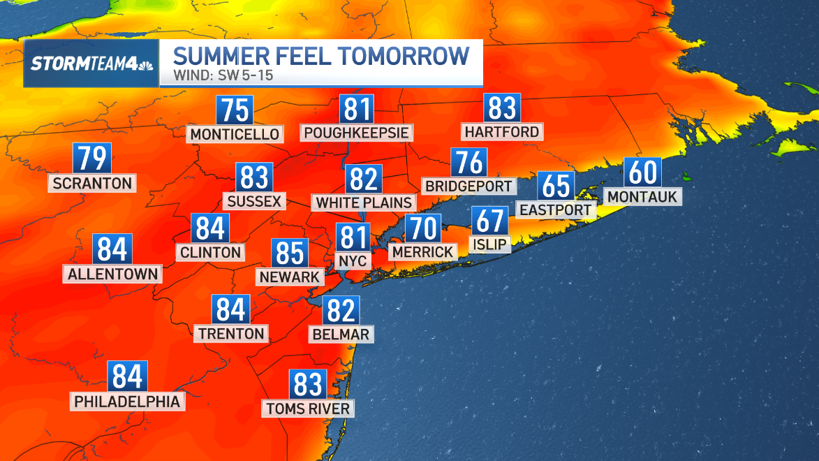
Hold on to your Easter bonnets, folks! The tri-state area is about to experience a serious temperature surge this Easter weekend. We're talking about highs climbing into the low to mid 80s – a welcome change for those of us who have been patiently waiting for warmer weather. Dust off your shorts, break out the sunscreen, and prepare for a weekend that feels more like June than April. But before you pack away your sweaters completely, there’s a slight catch. Keep reading to see if your area is set to bake or stay cool!
The Good News: Widespread Warmth is Coming
For a large portion of the tri-state, Easter weekend is shaping up to be spectacularly warm. Imagine strolling through the park, enjoying an outdoor picnic, or simply soaking up the sun without a heavy jacket. This is the kind of Easter that photo albums are made for! Many inland areas can expect those delightful 80-degree readings.
What areas will experience the heat?
If you’re located away from the immediate coast, chances are you're in for a treat. Think inland New Jersey, the Hudson Valley, and areas further inland on Long Island. This warmth is a fantastic opportunity to get outside and enjoy the blossoming spring weather.
The (Slight) Catch: Coastal Coolness
Now, for the asterisk. Mother Nature loves to play tricks, and this time, the trick involves the ocean.
The Impact of Onshore Winds
Those living along the immediate south-facing shores of Long Island and the Connecticut coast might find themselves feeling a little left out of the heatwave. A southwest wind, acting as an onshore breeze, will pull cool ocean air ashore, keeping temperatures significantly lower. Think 50s and 60s instead of 80s.
Why does this happen?
The ocean acts as a temperature regulator. Water heats up and cools down much slower than land. So, while the land basks in the warm sunshine, the ocean remains relatively cool, and the onshore wind brings that cool air inland.
Decoding the Weather Map: Where Will It Be Warmest?
Understanding the weather map can help you plan your Easter weekend activities.
Focusing on Inland Areas
Pay close attention to the areas furthest away from the coast. These are the spots where the warm air will have the least amount of ocean influence. Look for gradients – the further inland you go, the warmer it will likely be.
Coastal Regions: Microclimates Matter
Even within coastal areas, there can be microclimates. A small bay or sheltered cove might experience slightly warmer temperatures than an exposed beach. Keep an eye on local weather reports for the most accurate predictions.
Making the Most of a Warm Easter: Activity Ideas
Okay, so you know it's going to be warm. Now what? Let’s brainstorm some fun Easter weekend activities.
Outdoor Easter Egg Hunt Extravaganza
What better way to celebrate a warm Easter than with an outdoor egg hunt? Find a local park, set up a backyard hunt, or even organize a neighborhood-wide event. Imagine the kids running around in shorts and t-shirts, basking in the sunshine while searching for hidden treasures.
Spring Cleaning and Gardening
Feeling productive? Use the warm weather as motivation to tackle some spring cleaning or get your garden started. Planting flowers, raking leaves, and washing windows are all much more enjoyable when the sun is shining.
Outdoor Dining and Picnics
Pack a picnic basket, grab a blanket, and head to your favorite park or scenic spot. Enjoy a delicious meal al fresco, soaking up the sunshine and fresh air. Don't forget the sunscreen!
Fashion Forecast: Dressing for the Heat (or Not)
What to wear this Easter weekend? It all depends on your location.
Embrace the Shorts and T-Shirt Look
If you're in one of the warmer inland areas, shorts, t-shirts, sundresses, and sandals are all perfectly appropriate. Think light, breathable fabrics that will keep you comfortable in the heat.
Layer Up for Coastal Coolness
If you're near the coast, layering is key. A light jacket, sweater, or long-sleeved shirt will be your best friend. Be prepared for a temperature drop, especially in the evening.
Safety First: Sun Protection and Hydration
With warmer weather comes increased sun exposure. It's important to protect yourself from the sun's harmful rays.
Sunscreen is Your Best Friend
Apply sunscreen liberally and often, especially if you're spending a lot of time outdoors. Don't forget to reapply every two hours, or more frequently if you're swimming or sweating.
Stay Hydrated
Drink plenty of water throughout the day to stay hydrated. Avoid sugary drinks, which can actually dehydrate you. Carry a reusable water bottle with you and refill it frequently.
Looking Ahead: Will the Warm Weather Stick Around?
Is this a sign of things to come? Is summer arriving early? While it's too early to say for sure, this warm spell is certainly a welcome preview of the warmer months ahead. Keep an eye on the long-range forecast to see if the trend continues.
Following Long-Term Trends
Analyzing long-term weather patterns can provide insights into potential seasonal changes. Checking reliable weather sources regularly will help you stay informed.
Understanding the Science Behind the Sudden Warmth
What's causing this sudden surge in temperatures?
High Pressure Systems and Air Masses
A high-pressure system is moving in, bringing with it a warm air mass. This warm air mass originates from further south, pushing temperatures up across the tri-state area. High-pressure systems typically bring clear skies and calm winds, further contributing to the warm weather.
Jet Stream Dynamics
The position of the jet stream also plays a role. When the jet stream dips south, it allows colder air to move down from the north. Conversely, when it shifts north, it allows warmer air to move up from the south.
The Importance of Reliable Weather Sources
With so much conflicting information online, it's crucial to rely on trustworthy weather sources.
Trusted News Outlets
Stick to reputable news outlets and weather channels that have a team of experienced meteorologists. These sources provide accurate and up-to-date information.
Official Government Sources
The National Weather Service (NWS) is a reliable source for weather forecasts and warnings. Their website and mobile app provide valuable information.
The Impact on Local Businesses
How will this warm Easter weekend affect local businesses?
Boost for Outdoor Retailers
Expect a surge in sales for outdoor retailers, including stores that sell gardening supplies, sporting goods, and summer clothing. People will be eager to stock up on items for outdoor activities.
Restaurants and Cafes with Outdoor Seating
Restaurants and cafes with outdoor seating will likely see an increase in business. Customers will be eager to enjoy a meal or drink in the sunshine.
Celebrating Easter in Style: Tips and Tricks
Regardless of whether you're basking in the heat or enjoying a cool coastal breeze, there are plenty of ways to celebrate Easter in style.
Decorating with Spring Colors
Embrace the vibrant colors of spring, such as pastel pinks, blues, and yellows. Decorate your home with flowers, Easter eggs, and other festive decorations.
Creating Memorable Moments
Spend quality time with loved ones, create lasting memories, and enjoy the simple pleasures of the season. Whether it's a family brunch, an Easter egg hunt, or a relaxing afternoon in the park, make the most of this special weekend.
Conclusion: A Memorable Easter Weekend Awaits
This Easter weekend promises a memorable experience for the tri-state area. While some will bask in summer-like heat, others will enjoy a refreshing coastal breeze. No matter your location, embrace the opportunity to spend time outdoors, connect with loved ones, and celebrate the arrival of spring. Remember to stay safe in the sun and stay informed by following reliable weather sources. Happy Easter!
Frequently Asked Questions (FAQs)
Here are some frequently asked questions about the upcoming Easter weekend weather:
- Will the warm weather extend into next week?
The long-range forecast is still evolving, but current indications suggest that temperatures may remain above average for the next week, although not necessarily at the same level as Easter weekend. Check back for updated forecasts. - Is this unusually warm for Easter?
Yes, temperatures in the low to mid 80s are higher than average for Easter in the tri-state area. Average high temperatures for this time of year are typically in the 50s and 60s. - What should I do if I'm allergic to pollen during this warm weather?
Pollen counts are likely to be high with the warm weather. Take your allergy medication as prescribed, keep windows closed, and consider using an air purifier. Limit your time outdoors during peak pollen hours. - Will the ocean temperature affect the coastal breeze temperature?
Absolutely! The ocean temperature is a key factor in determining the temperature of the onshore breeze. A colder ocean temperature will result in a cooler breeze. - Is there a chance of rain during the Easter weekend?
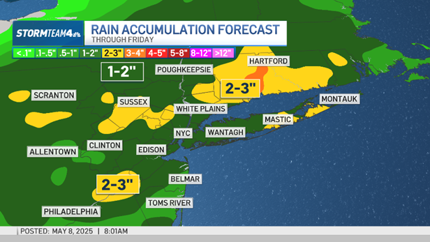
As of now, the forecast for Easter weekend looks dry and sunny. However, weather patterns can change quickly, so it's always a good idea to check the latest forecast before making your plans.

