Elevated Wildfire Danger: Tri-State Alert & NJ Peak Month

Elevated Wildfire Danger: Tri-State Alert & NJ Peak Month

Elevated Wildfire Danger: Tri-State Alert & NJ Peak Month

Brace Yourself: Elevated Wildfire Danger Grips Tri-State Area During NJ's Peak Fire Month

Introduction: A Burning Concern

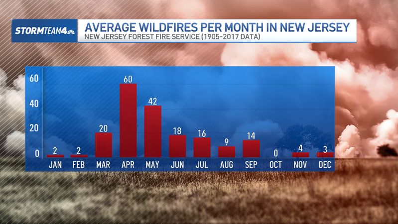
April showers bring May flowers… and, unfortunately, an increased risk of wildfires in the tri-state area. It’s that time of year again when dry conditions, gusty winds, and lingering winter debris combine to create a perfect storm for wildfires. It might seem counterintuitive to think of wildfires in the spring, but trust me, it's a real threat. As April, New Jersey’s peak fire month, comes to a close, we need to be aware and take precautions. Let’s dive into what’s causing this elevated wildfire danger and what we can do about it.

What Fuels the Flames? Understanding Wildfire Causes

Wildfires aren't just random acts of nature; they're often the result of a specific set of circumstances. Several factors contribute to the elevated wildfire danger we’re seeing right now.

Lingering Winter Debris

Think of your yard after a long winter. It’s probably littered with dead leaves, fallen branches, and dried grass. These materials act like kindling, providing ample fuel for a fire to start and spread rapidly. These natural fuels combined with an ignition source, either human or natural, and you’ve got a recipe for disaster.

Dry Conditions

April can be a fickle month, swinging between rainy days and stretches of dry weather. Even a few days without rain can significantly dry out vegetation, making it incredibly susceptible to ignition. It's like a sponge that's been left out in the sun – it becomes brittle and easily catches fire.

Breezy Weather

Wind is a wildfire's best friend. It not only helps dry out vegetation faster, but it also carries embers long distances, spreading the fire far beyond its initial source. A seemingly small brush fire can quickly turn into a raging inferno when the wind picks up. These embers, carried by the wind, can land on dry vegetation far from the original fire, creating new hotspots.

Human Activity

Sadly, human activity is a major contributor to wildfires. Carelessly discarded cigarettes, improperly extinguished campfires, and even sparks from equipment can ignite dry vegetation. Think about it – a single spark from a lawnmower hitting a rock could be all it takes to start a devastating fire.

NJ's Unique Vulnerability: Why is New Jersey a Hotspot?

New Jersey, in particular, is susceptible to wildfires due to its unique landscape.

The Pine Barrens: A Tinderbox

The Pine Barrens, a vast expanse of pitch pine and scrub oak in southern New Jersey, is a particularly vulnerable area. The pitch pine is highly flammable, and the sandy soil drains quickly, leading to extremely dry conditions. It's like a giant, natural tinderbox just waiting for a spark.

Dense Population and Development

New Jersey is one of the most densely populated states in the US. This means that there’s a greater chance of human-caused ignitions, and more people living near areas prone to wildfires. This human-wildland interface, is a major risk factor.

Tri-State Area: A Regional Threat

The wildfire threat extends beyond New Jersey to the entire tri-state area, including New York and Connecticut.

Shared Weather Patterns

The tri-state area often experiences similar weather patterns, including periods of drought and high winds, which contribute to the elevated wildfire risk across the region. What happens in one state can easily impact the others.

Interconnected Landscapes

The forests and open spaces in the tri-state area are often interconnected, meaning that a wildfire that starts in one state can easily spread to another. We need to think of wildfire prevention as a regional effort.

Understanding Fire Danger Levels: What Do They Mean?

Fire danger levels are a crucial indicator of wildfire risk. They provide valuable information to both the public and emergency responders. Knowing what these levels mean can help you make informed decisions and take appropriate precautions.

Low, Moderate, High, Very High, Extreme

These are the most common fire danger levels, each representing a different level of risk. Low means the risk of wildfire is minimal, while Extreme means the risk is very high, and fires can start easily and spread rapidly.

Monitoring Tools: What the Experts Use

Fire officials use various tools and data to assess fire danger, including weather forecasts, fuel moisture levels, and historical fire data. By analyzing these factors, they can accurately predict the likelihood of wildfires.

Protecting Your Home and Property: Simple Steps, Big Impact

You might feel helpless against the threat of wildfires, but there's actually a lot you can do to protect your home and property.

Creating Defensible Space

Defensible space is the area around your home that you clear of vegetation and other flammable materials. This creates a buffer zone that can help slow or stop a wildfire from reaching your home. Think of it as building a protective wall around your house.

Maintaining Your Landscaping

Regularly mow your lawn, remove dead leaves and branches, and prune trees and shrubs. This reduces the amount of fuel available for a fire to burn. The key is to create a landscape that's less likely to ignite and spread fire.

Using Fire-Resistant Materials

When building or renovating your home, consider using fire-resistant materials, such as metal roofing, stucco siding, and tempered glass windows. These materials can help protect your home from embers and radiant heat. It's like giving your house a fireproof shield.

Staying Informed: Resources and Information

Staying informed is crucial during wildfire season. There are many resources available to help you stay up-to-date on current conditions and fire prevention tips.

Local News and Weather Reports

Pay attention to local news and weather reports, which will often provide updates on fire danger levels and any active wildfires in your area. These reports are your first line of defense against wildfire danger.

Government Websites and Agencies

Many government agencies, such as the New Jersey Forest Fire Service, provide valuable information on wildfire prevention and safety. Check their websites for tips, resources, and alerts. The state government is your go-to source for the most reliable information.

Emergency Alert Systems

Sign up for emergency alert systems, which will notify you of any immediate threats, such as wildfires or evacuations. These alerts can provide critical information when you need it most. Receiving those emergency alerts on your phone can save your life.

Safe Practices: Preventing Wildfires Every Day

Preventing wildfires is a community effort. By adopting safe practices every day, we can all help reduce the risk.

Properly Disposing of Cigarettes

Carelessly discarded cigarettes are a major cause of wildfires. Always extinguish cigarettes completely and dispose of them in a designated ashtray or container. Remember, a single discarded cigarette can start a catastrophic fire.

Safe Campfire Practices

If you're planning a campfire, be sure to clear a 10-foot area around the fire pit, keep water and a shovel nearby, and never leave the fire unattended. Always extinguish the fire completely before leaving. Campfires are great, but they can also be deadly if not handled properly.

Operating Equipment Safely

When operating equipment such as lawnmowers, chainsaws, or ATVs, be mindful of sparks. Avoid using equipment during dry, windy conditions, and keep a fire extinguisher nearby. These machines can easily start fires, so be extra careful.

The Long-Term Outlook: Adapting to a Changing Climate

Climate change is exacerbating the wildfire threat, making it even more important to take preventative measures. Warmer temperatures, longer droughts, and more extreme weather events are all contributing to increased wildfire risk.

Climate Change and Wildfires

As the climate changes, wildfires are becoming more frequent and intense. This trend is expected to continue in the coming years, so we need to adapt and prepare for a future with more wildfires. We need to start thinking about long-term solutions.

Community Resilience

Building community resilience is essential for mitigating the impacts of wildfires. This includes educating residents about fire safety, developing evacuation plans, and working together to protect our homes and communities. Working together, we can create stronger, more resilient communities.

Conclusion: A Call to Action

The elevated wildfire danger in the tri-state area during New Jersey’s peak fire month is a serious concern. By understanding the causes of wildfires, taking preventative measures, and staying informed, we can all help reduce the risk and protect our homes, communities, and natural resources. Let's all commit to being fire-safe and protecting the beautiful landscapes we call home. Stay vigilant, stay informed, and stay safe.

Frequently Asked Questions (FAQ)

1. What is the peak wildfire season in New Jersey?
The peak wildfire season in New Jersey is typically during the spring, particularly in April and May, and again in the fall, from October through December. These are the times when conditions are often driest and windier, making the state more susceptible to wildfires.
2. How can I find out the current fire danger level in my area?
You can find out the current fire danger level in your area by checking the website of the New Jersey Forest Fire Service or your local news and weather reports. These sources will provide updates on current conditions and any fire warnings or advisories.
3. What should I do if I see a wildfire?
If you see a wildfire, immediately call 911 or your local fire department. Provide them with the exact location of the fire and any other relevant details. If the fire is small and you feel confident in your ability to extinguish it safely, you can attempt to do so using water or a shovel. However, your safety should always be your top priority.
4. Does homeowners insurance cover wildfire damage?
Yes, most homeowners insurance policies cover damage caused by wildfires. However, it's important to review your policy to understand the specific coverage limits and any exclusions that may apply. Consider taking photos and videos of your property before a fire to simplify the claims process.
5. What are some fire-resistant plants I can use in my landscaping?
Some fire-resistant plants that are suitable for landscaping in the tri-state area include succulents, such as sedum and aloe; deciduous trees, such as oak and maple; and shrubs with high moisture content, such as rhododendrons and azaleas. Be sure to consult with a local nursery or landscaping expert to choose plants that are best suited for your specific location and soil conditions.
Tri-State Under Thunderstorm Watch: Stay Safe!

Tri-State Under Thunderstorm Watch: Stay Safe!

Tri-State Under Thunderstorm Watch: Stay Safe!

Tri-State Under the Gun: Severe Thunderstorm Watch Issued!

Introduction: Brace Yourselves, Storms Are Brewing!

Hey there, folks! Looks like Mother Nature has a bit of a temper tantrum planned for the tri-state area this weekend. Showers and storms, some potentially packing a serious punch, are heading our way. Get ready for a stormy evening and overnight – it’s going to be a wild ride!

A severe thunderstorm watch has been issued for a large chunk of Connecticut, the upper Hudson Valley, and northern New Jersey until 11 p.m. tonight. This isn't just a little sprinkle; we're talking about the possibility of some serious weather.

Understanding the Thunderstorm Watch

What Does a Thunderstorm Watch Mean?

So, what does a thunderstorm watch actually *mean*? Think of it as a heads-up. It means that conditions are favorable for severe thunderstorms to develop in the specified area. It's like the universe whispering, "Hey, potential for trouble ahead, so keep an eye out!"

Where is the Watch in Effect?

Specifically, the severe thunderstorm watch covers most of Connecticut, encompassing areas like Hartford, New Haven, and Litchfield counties. It also extends into the upper Hudson Valley in New York, including counties like Dutchess and Ulster, and parts of Northern New Jersey. Check your local news for the most up-to-date and specific information for your location.

The I-95 Corridor: Ground Zero for Storm Activity?

The experts are saying that the highest concentration of these storms is likely to set up along and west of the I-95 corridor. If you're in this area, pay extra close attention to weather updates. This is where we're most likely to see strong winds, torrential downpours, and those electrifying lightning strikes. It's like the storm's preferred highway, unfortunately.

Potential Hazards: Wind, Rain, and Lightning, Oh My!

Strong Winds: Nature's Demolition Crew

We're not just talking about a gentle breeze here. These storms could bring strong, gusty winds capable of downing trees and power lines. Imagine the wind as a powerful, invisible hand, pushing and shoving everything in its path. Secure loose objects in your yard, like patio furniture and trash cans, before the storm hits.

Heavy Downpours: Flooding Concerns

Prepare for a deluge! The heavy downpours could lead to localized flooding, especially in low-lying areas. It's like the sky turning into a giant, leaky faucet. Be extra cautious when driving, and avoid areas prone to flooding. Remember the saying: "Turn around, don't drown!"

Abundant Lightning: A Shocking Display

Lightning is a beautiful, but incredibly dangerous, phenomenon. These storms are expected to bring a lot of it. Remember the 30/30 rule: If you can count 30 seconds or less between seeing lightning and hearing thunder, take shelter immediately. Stay indoors for at least 30 minutes after hearing the last clap of thunder. Think of lightning as nature's way of saying, "Stay inside, it's electrifyingly unsafe out here!"

Staying Safe During a Thunderstorm

Indoor Safety: Your Castle in the Storm

The best place to be during a thunderstorm is inside a sturdy building. Remember, a car is *not* a safe place. It's a metal box that attracts lightning. Stay away from windows and doors, and avoid contact with metal objects and electrical appliances. Unplug electronics if you can, but don't risk your safety to do so.

Outdoor Safety: When You Can't Get Inside

If you're caught outside during a thunderstorm, seek shelter in a low-lying area, but be aware of potential flooding. Crouch down with your head between your knees, minimizing your contact with the ground. Stay away from tall objects like trees, which can attract lightning. Think of it as playing a really intense game of weather hide-and-seek.

Preparing Your Home for the Storm

Securing Loose Objects: Prevent Flying Projectiles

Walk around your property and secure anything that could be blown away by strong winds, like patio furniture, garbage cans, and lawn decorations. These objects can become dangerous projectiles in high winds, causing damage and injury. Think of it as giving your yard a pre-storm "tidy up."

Checking Your Gutters and Drains: Prevent Water Damage

Make sure your gutters and drains are clear of debris to prevent water from backing up and potentially causing damage to your home. Clogged gutters can lead to water damage to your roof, siding, and foundation. It’s like giving your house a "raincoat check" to ensure it's ready for the downpour.

Power Outages: Prepare for the Dark

Power outages are a common occurrence during thunderstorms. Prepare for the possibility of losing power by having flashlights, batteries, and a battery-powered radio on hand. Consider investing in a generator if you live in an area prone to frequent power outages. Charge your cell phones and other electronic devices ahead of time.

Monitoring the Weather: Stay Informed

Local News Outlets: Your Weather Lifeline

Stay tuned to your local news outlets for the latest weather updates and warnings. They provide real-time information and can help you stay ahead of the storm. Think of them as your personal weather informants.

Weather Apps and Websites: Information at Your Fingertips

Download weather apps and bookmark weather websites on your phone and computer. These resources provide detailed weather information, including radar imagery, forecasts, and alerts. It's like having a pocket-sized weather expert with you at all times.

The Aftermath: Assessing the Damage and Recovery

Inspecting Your Property: Looking for Damage

After the storm passes, carefully inspect your property for any damage. Look for downed trees, power lines, and damage to your roof, siding, and windows. Be especially cautious around downed power lines, as they can be extremely dangerous. Think of it as giving your property a post-storm "check-up."

Reporting Damage: Filing Insurance Claims

If you experience any damage to your property, document it with photos and videos and report it to your insurance company as soon as possible. They can help you assess the damage and file a claim for repairs. It's like calling in the professionals to help you get back on your feet.

Helping Your Neighbors: Community Support

Check on your neighbors, especially those who are elderly or have disabilities, to see if they need any help. Community support is crucial during times of crisis. It's like lending a helping hand to those who need it most.

The Science Behind Thunderstorms: A Quick Look

How Thunderstorms Form: Warm Air and Moisture

Thunderstorms form when warm, moist air rises into the atmosphere. As the air rises, it cools and condenses, forming clouds. If there's enough instability in the atmosphere, these clouds can develop into towering cumulonimbus clouds, which are the hallmark of thunderstorms. Think of it like a recipe: warm air, moisture, and instability are the key ingredients.

The Role of Lightning: Static Electricity in the Sky

Lightning is a discharge of static electricity that builds up in thunderstorm clouds. The exact mechanism is still not fully understood, but it's believed that ice crystals and water droplets collide in the clouds, creating a separation of charge. When the electrical potential becomes strong enough, a spark jumps between the clouds or between the clouds and the ground. It's like a giant, natural Van de Graaff generator in the sky.

Conclusion: Stay Alert, Stay Safe

Alright folks, that’s the rundown! A severe thunderstorm watch is in effect for the tri-state area, bringing the potential for strong winds, heavy downpours, and abundant lightning. Stay informed, take precautions, and most importantly, stay safe. Keep an eye on the sky, listen to your local news, and be prepared for a potentially stormy evening and overnight. Remember, it's always better to be safe than sorry when it comes to severe weather. Be prepared to take action if the thunderstorm watch turns into a thunderstorm warning.

Frequently Asked Questions (FAQs)

  1. What's the difference between a thunderstorm watch and a thunderstorm warning? A watch means conditions are favorable for thunderstorms to develop. A warning means a thunderstorm is already occurring and poses a threat to life and property.
  2. Is it safe to take a shower during a thunderstorm? No. Avoid contact with water during a thunderstorm, as pipes can conduct electricity.
  3. Should I unplug my electronics during a thunderstorm? Yes, it's a good idea to unplug electronics to protect them from power surges caused by lightning strikes.
  4. What should I do if I see a downed power line? Stay away from it and call your local utility company immediately. Downed power lines can be extremely dangerous.
  5. How can I prepare my pet for a thunderstorm? Provide a safe, quiet space for your pet to retreat to during the storm. Some pets may benefit from anxiety-reducing products or medications.
Severe Storms This Weekend: What Tri-State Needs to Know

Severe Storms This Weekend: What Tri-State Needs to Know

Severe Storms This Weekend: What Tri-State Needs to Know

Weekend Weather Alert: Isolated Strong-to-Severe Storms Threaten Your Friday and Saturday

Introduction: Bracing for Another Round of Storms

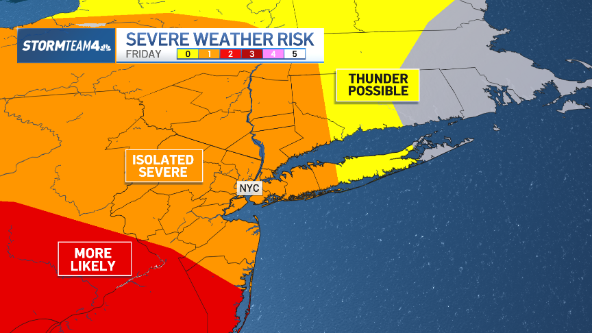
Remember that feeling of finally packing away the umbrellas, only to realize you need them again the next day? Well, here we go again! For the second week running, we've been navigating cloudy skies and the accompanying rain. While Wednesday bore the brunt of this week's rainfall, the weather isn't quite done with us yet. We're keeping a close eye on the potential for isolated strong-to-severe storms across the tri-state area on both Friday and Saturday. So, what do you need to know to prepare? Let's dive in!

What's Brewing: The Atmospheric Setup

To understand what's going on, let's look at the big picture. The atmosphere is like a giant puzzle, with different pieces – temperature, moisture, and pressure – all interacting. Right now, we've got a few key ingredients coming together that could spell trouble.

Moisture, Instability, and Lift: The Recipe for Storms

Think of these as the key ingredients in a storm recipe. We've got plenty of moisture in the air, providing the fuel for storms to develop. We also have instability, which is like a tightly wound spring – it's the potential energy that allows storms to become strong. And finally, we need a "trigger" – something to lift that moist, unstable air and kick things off. This "lift" can come from things like fronts, upper-level disturbances, or even just the terrain.

Timing is Everything: When to Expect the Storms

So, when exactly should you be on alert? Here's a breakdown of the expected timeline:

Friday's Forecast: Isolated Afternoon and Evening Threat

Friday's primary threat window will be in the afternoon and evening hours. As the sun heats the ground, the atmosphere will become even more unstable, increasing the chances of storm development. The exact timing and location of these storms are still somewhat uncertain, but it's best to be prepared.

Saturday's Outlook: Similar Pattern, Slightly Higher Potential

Saturday looks like a repeat of Friday, with a similar atmospheric setup. However, some models suggest that the overall potential for strong-to-severe storms could be slightly higher on Saturday. Keep in mind that the forecast can change, so it’s wise to check the forecast before you leave home.

The Risks: What Kind of Weather to Expect

What exactly do we mean by "strong-to-severe" storms? Here's what to watch out for:

Damaging Winds: A Widespread Threat

Damaging winds are likely to be the primary threat with these storms. Think of it like this: imagine someone swinging a baseball bat through the air. Strong winds can do significant damage, knocking down trees, power lines, and causing structural damage.

Large Hail: An Icy Assault

Large hail is another possibility. Hailstones can range in size from small peas to golf balls (or even larger!), and they can cause significant damage to cars, roofs, and crops. Imagine being bombarded by icy projectiles falling from the sky.

Heavy Rain: Potential for Flash Flooding

Heavy rainfall is also a concern. If storms linger over the same area for an extended period, it could lead to flash flooding. This is especially true in urban areas where drainage systems can be overwhelmed. It is always important to avoid flood water on the roads.

Isolated Tornadoes: A Low, But Non-Zero, Risk

While the overall risk of tornadoes is relatively low, it's not zero. Tornadoes are localized, intense columns of rotating air that can cause catastrophic damage. Stay informed and know what to do if a tornado warning is issued.

Staying Safe: Your Action Plan

Now that you know the risks, let's talk about how to stay safe.

Staying Informed: Monitor Weather Updates

The most important thing you can do is stay informed. Monitor local weather forecasts from reliable sources like the National Weather Service or your local news. Pay attention to any watches or warnings that are issued.

Have a Plan: Prepare for Potential Power Outages

Power outages are a common occurrence during severe storms. Make sure you have a flashlight, battery-powered radio, and extra batteries on hand. Consider investing in a generator if you rely on electricity for medical equipment or other essential needs.

Seek Shelter: Know Where to Go

If a severe thunderstorm warning is issued for your area, seek shelter immediately. The safest place to be is indoors, in a sturdy building, away from windows. If you live in a mobile home, find a designated shelter or a sturdy building nearby.

Driving Precautions: Avoid Flooded Areas

Never drive through flooded areas. The water may be deeper than it appears, and even a few inches of moving water can sweep away a car. Turn around, don’t drown!

Long-Term Preparedness: Being Ready for Anything

Beyond the immediate threat of this weekend's storms, it's a good idea to have a general emergency preparedness plan in place.

Emergency Kit: Stock Up on Essentials

Assemble an emergency kit with enough supplies to last for at least three days. Include things like food, water, first-aid supplies, medications, and personal hygiene items.

Communication Plan: Stay in Touch with Loved Ones

Have a communication plan so you can stay in touch with family and friends in case of an emergency. Designate a meeting place if you become separated.

The Bigger Picture: Why Are We Seeing More Severe Weather?

It's natural to wonder if there's a reason we seem to be experiencing more frequent and intense weather events. While it's difficult to attribute any single event directly to climate change, scientists agree that a warming climate is likely to lead to more extreme weather in the future.

Climate Change and Severe Weather: The Connection

A warmer atmosphere can hold more moisture, which can fuel stronger storms. Changes in atmospheric patterns can also lead to more frequent and prolonged heat waves, droughts, and heavy rainfall events.

Conclusion: Stay Vigilant and Stay Safe

This weekend, the tri-state area faces the potential for isolated strong-to-severe storms. Remember to stay informed, have a plan, and seek shelter if necessary. The main threats are damaging winds, large hail, heavy rain, and a low risk of tornadoes. While we hope these storms pass without incident, preparation is key to ensuring your safety. Stay vigilant, and stay safe!

Frequently Asked Questions (FAQs)

  1. What's the difference between a severe thunderstorm watch and a severe thunderstorm warning?
    A watch means that conditions are favorable for severe thunderstorms to develop in the area. A warning means that a severe thunderstorm has been sighted or indicated by radar and is imminent in your location.
  2. What should I do if I'm caught outside during a severe thunderstorm?
    Seek shelter immediately in a sturdy building. If no building is available, find a low-lying area away from trees and power lines. Crouch down and cover your head.
  3. How large does hail have to be to be considered severe?
    Hail is classified as severe when it is 1 inch in diameter or larger (about the size of a quarter).
  4. What's the safest place to be in my house during a tornado?
    The safest place is an interior room on the lowest level, away from windows. A basement is ideal. If you don't have a basement, a closet or hallway is a good option.
  5. How can I prepare my home for severe weather?
    Trim trees and shrubs that could fall on your house. Secure loose objects, such as patio furniture. Consider installing storm shutters or reinforcing windows. Have a generator ready in case of power outages.