NJ Wildfire Alert: High Fire Risk & Safety Tips

NJ Wildfire Alert: High Fire Risk & Safety Tips

NJ Wildfire Alert: High Fire Risk & Safety Tips

NJ Wildfire Alert: High Fire Risk Amid Gusty Winds and Low Humidity

Introduction: A Tinderbox Situation in the Garden State

Imagine New Jersey as a beautiful garden. Now, imagine that garden becoming incredibly dry, with the wind whipping through like a mischievous child scattering leaves. That's the situation we're facing right now. Forecasters are sounding the alarm about an elevated fire risk across New Jersey, Philadelphia and its suburbs, and Delaware, as firefighters continue to battle the tenacious Jones Road Wildfire in the Pine Barrens. But what makes this such a precarious situation? Let's dive in and understand the perfect storm brewing in our backyard.

The Jones Road Wildfire: An Ongoing Battle

The Jones Road Wildfire is the spark that ignited this heightened awareness. While details are still emerging, the sheer size and persistence of the blaze highlight the vulnerability of our landscapes during these conditions. The fire serves as a stark reminder of the destructive power of wildfires and the importance of vigilance. How can we help prevent further outbreaks?

Location and Impact

The fire's location in the Pine Barrens, a unique and ecologically significant region, adds another layer of concern. This area is known for its sandy soil, pitch pines, and diverse plant and animal life. A large-scale fire could have devastating consequences for this delicate ecosystem.

Firefighting Efforts

Brave firefighters are working tirelessly to contain the Jones Road Wildfire. Their efforts are hampered by the very conditions that fueled the fire in the first place: low humidity and strong winds. We owe them a debt of gratitude for their dedication and sacrifice.

Weather Woes: Low Humidity and Gusty Winds

The National Weather Service has issued warnings about the dangerous combination of low humidity and gusty winds. But what do these conditions actually mean for fire risk?

Understanding Low Humidity

Low humidity means there's very little moisture in the air. Think of it like a sponge that's been left out in the sun. It becomes dry and brittle, easily igniting. In this scenario, even a small spark can quickly escalate into a raging inferno.

The Impact of Gusty Winds

Winds act like a fan, feeding a fire with oxygen and spreading embers over a wider area. Gusty winds are even more dangerous because they are unpredictable and can quickly change direction, making it difficult for firefighters to control the flames. Imagine trying to steer a kite in a hurricane - that's how challenging it can be to fight a wildfire in these conditions.

Temperatures on the Rise

The National Weather Service also noted that temperatures were expected to reach near 80 degrees on Friday. Higher temperatures further dry out vegetation, making it even more susceptible to ignition. It's a triple threat: low humidity, gusty winds, and rising temperatures.

The Mid-Atlantic at Risk: A Broad Threat

The elevated fire risk isn't limited to New Jersey alone. Philadelphia, its suburbs, and Delaware are also facing similar conditions. This highlights the regional nature of the threat and the importance of widespread awareness and preventative measures.

Philadelphia and its Suburbs

Urban and suburban areas aren't immune to wildfire risk. Dry grass, overgrown brush, and improperly discarded cigarettes can all ignite a fire, especially when conditions are favorable. It's crucial for residents to be vigilant and take precautions.

Delaware's Vulnerability

Delaware's coastal landscapes and wooded areas are also susceptible to wildfires. The state's small size doesn't diminish the potential for damage. Preventative measures are just as important in Delaware as they are in New Jersey and Pennsylvania.

Outdoor Burning: A Definite No-Go

The National Weather Service has strongly discouraged any outdoor burning. This includes campfires, bonfires, and even controlled burns. The risk of a small fire escalating into a large, uncontrollable blaze is simply too high. Is that marshmallow really worth risking a wildfire?

Alternatives to Outdoor Burning

If you need to dispose of yard waste, consider composting or contacting your local municipality for disposal options. There are many alternatives to burning that are safer and more environmentally friendly.

Penalties for Illegal Burning

Ignoring the burn ban can result in hefty fines and even criminal charges. It's simply not worth the risk. Protect yourself, your community, and the environment by adhering to the regulations.

Hope on the Horizon: A Chance of Rain

There's a glimmer of hope in the forecast: a chance of rain over the weekend. While not a guaranteed solution, even a small amount of rain could help dampen the landscape and reduce the fire risk. Let's keep our fingers crossed for some much-needed precipitation.

The Importance of Rain

Rain helps to increase humidity and saturate vegetation, making it less likely to ignite. It also helps to suppress existing fires, making it easier for firefighters to control them.

Preparing for the Next Dry Spell

Even if it rains, it's important to remember that dry conditions can return quickly. We need to be prepared for future fire risks by maintaining our properties, being vigilant about potential ignition sources, and staying informed about weather conditions.

Protecting Your Property: Simple Steps to Take

There are several simple steps you can take to protect your property from wildfires.

Creating Defensible Space

Clear away dry leaves, brush, and debris from around your home. This creates a buffer zone that can help to slow the spread of fire. Think of it as creating a personal safety zone around your house.

Maintaining Your Lawn

Keep your lawn mowed and watered. Dry grass is a fire hazard. A well-maintained lawn is less likely to ignite.

Inspecting Your Gutters

Clean out your gutters regularly to remove dry leaves and debris. These can easily ignite and spread fire to your roof.

Community Vigilance: Reporting Suspicious Activity

If you see smoke or fire, report it immediately to your local fire department. Also, be on the lookout for suspicious activity that could lead to a fire. Early detection is crucial in preventing wildfires.

Staying Informed: Weather Updates and Alerts

Stay informed about weather updates and alerts from the National Weather Service and your local news outlets. Knowing the current fire risk can help you make informed decisions about outdoor activities.

Conclusion: Staying Safe and Vigilant

The combination of low humidity, gusty winds, and the ongoing Jones Road Wildfire creates a heightened fire risk across New Jersey, Philadelphia, and Delaware. By taking preventative measures, being vigilant about potential ignition sources, and staying informed about weather conditions, we can all help to reduce the risk of wildfires and protect our communities. Remember, even a small spark can have devastating consequences. Let's work together to keep our landscapes safe.

Frequently Asked Questions (FAQs)

Here are some frequently asked questions about wildfire risk and prevention:

  1. Why is low humidity a fire risk? Low humidity means there's less moisture in the air, causing vegetation to dry out and become highly flammable. Think of it like a dry sponge – it ignites much easier than a damp one.
  2. How do gusty winds contribute to wildfires? Gusty winds act like a bellows, fanning the flames and spreading embers over a wider area. This makes it harder to control the fire and can quickly escalate the situation.
  3. What can I do to protect my home from wildfires? Create defensible space by clearing away dry leaves and brush around your home, keep your lawn mowed and watered, and clean out your gutters regularly.
  4. What should I do if I see a wildfire? Report it immediately to your local fire department. Provide them with as much detail as possible about the location and size of the fire.
  5. Where can I find more information about wildfire prevention? Contact your local fire department, forestry service, or emergency management agency. They can provide you with valuable resources and information about wildfire prevention in your area.
NYC Storm Alert: Severe Weather Threatens PM Commute!

NYC Storm Alert: Severe Weather Threatens PM Commute!

NYC Storm Alert: Severe Weather Threatens PM Commute!

NYC Weather Alert: Strong Storms Threaten PM Commute!

Introduction: Is NYC Bracing for a Stormy Commute?

Gloomy weather getting you down, New Yorkers? You're not alone! It looks like we're stuck with it for at least today. But it's not just gloomy skies we have to worry about. There's a chance of some real weather brewing. Are we prepared for potential disruption?

Strong to severe thunderstorms are expected to develop this afternoon, potentially wreaking havoc on the evening commute, especially in areas west of the city. So, grab your umbrellas, charge your phones, and let's dive into what we can expect.

Understanding the Increasing Severe Weather Risk

While a widespread, catastrophic event is not currently predicted, the risk of severe weather is definitely ticking upwards for the NYC metro area. Think of it like a dial slowly turning from "calm" to "watch out!"

What Does "Increasing Risk" Mean?

Increasing risk means that the atmospheric conditions are becoming more favorable for thunderstorms to intensify and potentially reach severe levels. It doesn't guarantee severe weather, but it does heighten the possibility. Are we prepared for that possibility?

Where is the Risk Concentrated?

Right now, the areas west of NYC seem to be most at risk, including parts of central and northern New Jersey, as well as the Catskills and Hudson Valley in New York.

The Biggest Threats: Wind and Hail

The primary concerns with these potential storms are damaging wind and hail. These elements can cause power outages, property damage, and pose a risk to anyone caught outdoors.

Damaging Wind: More Than Just a Breeze

We're not talking about a gentle gust of wind here. Damaging winds can reach speeds high enough to knock down trees, power lines, and even cause structural damage to buildings. Imagine the chaos on the roadways!

Hail: Ice Balls from the Sky

Hail can range in size from pea-sized to golf ball-sized (or even larger in extreme cases!). Even small hail can damage cars and crops, while larger hail can be downright dangerous.

Timing is Everything: The PM Commute Factor

The timing of these storms is particularly concerning because they are expected to hit during the evening commute. This is when millions of people are traveling home from work, school, and other activities. This means an increased risk of accidents and delays.

Stay Updated on Changing Conditions

The forecast can change rapidly. Make sure to monitor weather updates from trusted sources, such as the National Weather Service, local news channels, and weather apps, throughout the day. Consider downloading a weather app with alerts.

Plan Ahead to Minimize Exposure

If possible, adjust your commute to avoid the peak storm hours, which are currently predicted to be between mid-afternoon and early evening. If that's not possible, be prepared for delays and potential detours. Maybe take that half day you've been meaning to take.

Affected Areas: Which Communities Are at Risk?

As mentioned earlier, the highest risk areas include:

  • Central and northern New Jersey
  • The Catskills region of New York
  • The Hudson Valley region of New York
  • Specifically, Ulster and Dutchess counties in New York

Regional Variations in Storm Severity

Even within these regions, the severity of the storms can vary. Some areas may experience heavy rain and lightning, while others may face more intense wind and hail. Keep an eye on your specific location's forecast.

Safety Tips: Protecting Yourself and Your Property

When severe weather threatens, it's always better to be safe than sorry. Here are some key safety tips to keep in mind:

  • Seek shelter indoors: The safest place to be during a thunderstorm is inside a sturdy building.
  • Stay away from windows: Flying debris can shatter windows and cause injuries.
  • Avoid electrical appliances and plumbing: Lightning can travel through these systems.
  • If driving, pull over: If you're caught in a storm while driving, pull over to a safe location and wait for it to pass.
  • Secure outdoor objects: Bring in loose items like lawn furniture, trash cans, and decorations that could be blown away by the wind.

Emergency Preparedness: Do You Have a Plan?

Take some time now to review your emergency plan. Make sure you have a supply of non-perishable food, water, and a flashlight in case of power outages. Do you have a meeting place designated for your family?

Understanding Severe Weather Alerts

The National Weather Service (NWS) issues different types of alerts to warn the public about impending severe weather. Knowing the difference between these alerts is crucial for taking appropriate action.

Severe Thunderstorm Watch vs. Warning

A Severe Thunderstorm Watch means that conditions are favorable for severe thunderstorms to develop in the area. A Severe Thunderstorm Warning means that a severe thunderstorm has been spotted or indicated by radar and is imminent or occurring in the area. A warning requires immediate action.

How to Stay Informed About Alerts

Sign up for weather alerts through your local news channels, weather apps, or the NWS website. Make sure your wireless emergency alerts are enabled on your smartphone.

Longer-Term Forecast: Is This the New Normal?

While it's impossible to predict the future with certainty, climate change is expected to increase the frequency and intensity of severe weather events in many areas, including the Northeast. Are we seeing a pattern emerging?

Adapting to a Changing Climate

This means we need to adapt our infrastructure and emergency preparedness plans to better cope with the challenges of a changing climate. This includes investing in more resilient power grids, improving drainage systems, and educating the public about severe weather safety.

The Role of Technology in Weather Forecasting

Advances in technology have dramatically improved our ability to forecast severe weather. Sophisticated weather models, radar systems, and satellite imagery provide valuable data that helps meteorologists predict storms with greater accuracy. Has all of this technology made us any safer?

Leveraging Weather Apps and Online Resources

Take advantage of weather apps and online resources to stay informed about current conditions and future forecasts. These tools can provide real-time updates, personalized alerts, and valuable safety information.

Community Resilience: Working Together During Severe Weather

Severe weather events can bring communities together. Neighbors help neighbors, emergency responders provide assistance, and volunteers pitch in to help with cleanup efforts. How strong is your community spirit?

Supporting Local Emergency Responders

Support your local emergency responders by volunteering your time, donating to organizations that provide assistance to disaster victims, and following their instructions during severe weather events. They are on the front lines!

Inspecting Your Property Before and After a Storm

Before a storm hits, inspect your property for potential hazards, such as loose tree branches or damaged roofing. After a storm, carefully inspect your property for any damage and take steps to repair it as soon as possible.

Documenting Damage for Insurance Claims

If your property sustains damage from a storm, document it thoroughly with photos and videos. This will be helpful when filing an insurance claim. Keep receipts for any repairs you make.

Protecting Your Vehicles from Hail and Wind

If possible, park your vehicles in a garage or carport to protect them from hail and wind. If that's not possible, cover them with blankets or tarps to minimize damage. Remember, a little prevention goes a long way.

Understanding Your Auto Insurance Coverage

Review your auto insurance policy to understand your coverage for hail and wind damage. Make sure you have adequate coverage to protect your vehicles in the event of severe weather.

Staying Connected During a Power Outage

Power outages are a common occurrence during severe weather events. Make sure you have a plan for staying connected to the outside world in the event of a power outage. This includes having a charged portable charger for your phone, a battery-powered radio, and a way to access the internet.

Conserving Battery Power on Electronic Devices

During a power outage, conserve battery power on your electronic devices by turning off unnecessary features and reducing screen brightness. You might want to invest in a solar-powered charger.

Taking Care of Pets During Severe Weather

Don't forget about your furry friends during severe weather! Bring pets indoors and provide them with a safe and comfortable place to ride out the storm. Keep them away from windows and doors. Your pets are counting on you!

Pet Emergency Preparedness

Include your pets in your emergency preparedness plan. Make sure you have a supply of pet food, water, and any necessary medications. Consider microchipping your pets and keeping their tags up-to-date.

Mental Health Considerations During Severe Weather

Severe weather events can be stressful and anxiety-provoking. It's important to take care of your mental health during these times. Stay informed, but don't obsess over the news. Take breaks, practice relaxation techniques, and connect with friends and family. You're not alone in this!

Seeking Professional Help if Needed

If you're struggling to cope with the stress of severe weather, don't hesitate to seek professional help from a therapist or counselor. There are many resources available to support your mental health during challenging times.

Conclusion: Be Prepared and Stay Safe!

The possibility of strong to severe thunderstorms hitting the NYC area during the PM commute is a serious concern. Remember to stay informed, take necessary safety precautions, and be prepared for potential disruptions. By working together and staying vigilant, we can weather this storm and keep our communities safe. Stay safe out there!

Frequently Asked Questions

What is the difference between a severe thunderstorm and a regular thunderstorm?

A severe thunderstorm is defined as a thunderstorm that produces winds of 58 mph or greater, hail of 1 inch in diameter or greater, or a tornado. Regular thunderstorms are less intense and do not meet these criteria.

How can I prepare my home for a severe thunderstorm?

Secure loose outdoor objects, trim tree branches that could fall, clean gutters, and ensure your sump pump is working properly. Also, create an emergency kit with essential supplies.

What should I do if I am driving when a severe thunderstorm hits?

If possible, pull over to a safe location, such as a gas station or parking garage, and wait for the storm to pass. Avoid driving through flooded areas. If you must continue driving, slow down and turn on your headlights.

Is it safe to use my phone during a thunderstorm?

It is generally safe to use your cell phone during a thunderstorm, especially if you are indoors. However, avoid using corded phones, as lightning can travel through phone lines.

Where can I find the most up-to-date weather information for my area?

You can find the most up-to-date weather information from the National Weather Service (NWS) website, local news channels, and weather apps. Look for trusted sources that provide accurate and timely information.

Flash Flood Alert: NYC & Tri-State Braces for Heavy Rain!

Flash Flood Alert: NYC & Tri-State Braces for Heavy Rain!

Flash Flood Alert: NYC & Tri-State Braces for Heavy Rain!

New York Under the Rain: Flash Flood Watch as Heavy Rain Arrives!

Heads Up, Tri-State! Get Ready for a Wet Weekend

Alright New Yorkers, Mother Nature is at it again! We're expecting a deluge of rain to soak the tri-state area starting Thursday afternoon and lingering into Saturday. Think of it as Mother Nature's early tears of joy (or perhaps frustration with our collective weather complaints). This could mean a soggy end to the work week and potential flash flooding. But don't despair! There's a silver lining – the skies are expected to clear just in time for a gorgeous Mother's Day!

Thursday's Damp Start: The Pre-Weekend Drizzle

Remember that umbrella you swore you'd never forget again? Well, dig it out! Scattered showers are predicted to pop up by mid-afternoon on Thursday. These showers are expected to grow in intensity and coverage as the day progresses, meaning your evening commute could be a bit of a soggy mess, especially if you're north or west of the I-95 corridor. Consider yourself warned: plan accordingly! Think about it: is working from home an option? Maybe leave the office a tad early? It's always better to be prepared than to be caught in the rain!

Friday's Downpour: Get Ready for a Soaking

Hold on to your hats, folks! Thursday was just a warm-up. The real show starts overnight and continues into Friday morning. We're talking moderate to heavy rain possible throughout the entire day. Expect conditions to be consistently wet, with the heaviest rainfall predicted during the morning hours.

Rainfall Totals: How Much Can We Expect?

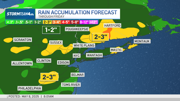
So, how much rain are we actually talking about? Experts predict total rainfall amounts of up to 2 inches across the region. But here's the kicker: some areas could see locally higher amounts. Translation: your particular neighborhood could get hit even harder. We're talking the potential for localized flooding, so keep a close eye on those low-lying areas!


Understanding Flash Flood Potential

Let’s talk about the elephant in the room: flash floods. What causes them, and why are we potentially at risk? Flash floods occur when rainfall exceeds the land's ability to absorb it, leading to rapid runoff. Considering the recent rainfall in some areas and the expected heavy downpours, the ground is already saturated. This increases the risk of flash flooding dramatically.

Factors Contributing to Flash Floods

  • Saturated Ground: The ground can't soak up any more water!
  • Heavy Rainfall Rates: Intense downpours overwhelm drainage systems.
  • Urban Areas: Pavement and concrete prevent water absorption.
  • Steep Terrain: Water flows downhill quickly, gathering momentum.

Interactive Radar: Your Weather Wingman

(Assume that the Javascript code for the interactive radar would be placed here).

Commuting Considerations: Navigating the Soggy Streets

Okay, let's get practical. How will this rain affect your commute? Public transportation could experience delays due to flooded tracks or signal issues. Road travel will be treacherous, with reduced visibility and hydroplaning risks. Bottom line: give yourself extra travel time and drive with extreme caution!

Safety Tips for Driving in Heavy Rain

  1. Slow Down: Reduce your speed significantly.
  2. Increase Following Distance: Give yourself more space to react.
  3. Turn on Headlights: Even during the day, headlights improve visibility.
  4. Avoid Standing Water: Hydroplaning is a real danger!
  5. Never Drive Through Flooded Roads: Turn around, don't drown!

Home Preparation: Protecting Your Property

Don't just think about the commute; think about your home! Take some proactive steps to minimize potential damage from the rain.

Protecting Your Home from Flooding

  • Clear Gutters and Downspouts: Ensure rainwater can flow freely away from your home.
  • Move Valuables: Raise valuable items off the floor in basements.
  • Check Sump Pumps: Ensure your sump pump is working correctly.
  • Seal Windows and Doors: Prevent water from seeping into your home.

Mother's Day Forecast: Sunshine and Smiles!

Now for the good news! While Friday might be a washout, the forecast for Mother's Day is looking spectacular. Expect sunshine, clear skies, and pleasant temperatures. Perfect weather to celebrate the amazing moms in our lives! So, plan that picnic, brunch, or outdoor activity – Mom deserves it!

Staying Informed: Your Weather Resources

It's crucial to stay updated on the latest weather forecasts and warnings. Here are some resources to keep you informed:

Reliable Weather Information Sources

  • Local News Channels: Check your local news for up-to-the-minute updates.
  • National Weather Service: The official source for weather information.
  • Weather Apps: Use reliable weather apps on your smartphone.
  • Emergency Alerts: Sign up for emergency alerts from your local government.

The Bigger Picture: Climate Change and Extreme Weather

While this specific weather event is just that – a weather event – it's important to consider the broader context of climate change. Are we seeing more frequent and intense rainfall events? Many scientists believe that climate change is contributing to more extreme weather patterns around the globe. Understanding the science behind climate change is crucial for preparing for the future.

Community Preparedness: Neighbors Helping Neighbors

During times of severe weather, it's essential to look out for your neighbors. Check in on elderly residents or those with disabilities. A little bit of kindness can go a long way in ensuring everyone's safety.

Flood Insurance: Is It Worth It?

Have you considered flood insurance? Standard homeowner's insurance policies typically don't cover flood damage. If you live in an area prone to flooding, flood insurance is definitely something to think about. It can provide crucial financial protection in the event of a flood.

Beyond the Rain: Dealing with Post-Storm Cleanup

Once the rain stops, the cleanup begins. Be cautious of downed power lines, standing water, and debris. Wear protective gear like gloves and boots when handling floodwater, as it can be contaminated. Safety should always be your top priority during the cleanup process.

Conclusion: Stay Safe and Prepared!

So, there you have it, New York! Heavy rain is on its way, potentially leading to flash floods. Stay informed, be prepared, and drive safely. Remember, this too shall pass, and beautiful Mother's Day weather is right around the corner! The key takeaways are: expect heavy rain, prepare for possible flooding, stay informed through trusted sources, and be cautious during commutes. But most importantly, stay safe and look out for each other!

Frequently Asked Questions

  1. What is the difference between a flash flood watch and a flash flood warning?

    A flash flood watch means that conditions are favorable for flash flooding to occur. A flash flood warning means that flash flooding is imminent or is already occurring. Take action immediately if a flash flood warning is issued for your area.

  2. How can I find out if my area is prone to flooding?

    Check with your local government or emergency management agency. They can provide flood zone maps and information about flood risks in your area.

  3. What should I do if I'm caught in a flash flood while driving?

    The safest thing to do is to abandon your vehicle and seek higher ground. However, if you are unable to safely exit the vehicle, stay inside and call for help. Never drive through flooded roads, as even shallow water can sweep your car away.

  4. How can I protect my car from flood damage?

    If possible, move your car to higher ground before the flooding begins. If you can't move your car, try to park it in a location that is less likely to flood, such as a parking garage or a high spot in a parking lot.

  5. Where can I get sandbags to protect my home from flooding?

    Contact your local government or emergency management agency. They may provide sandbags to residents in flood-prone areas. You can also purchase sandbags at hardware stores.

Flash Flood Watch: 2 Inches of Rain Threatens NY Area

Flash Flood Watch: 2 Inches of Rain Threatens NY Area

Flash Flood Watch: 2 Inches of Rain Threatens NY Area

New York Under Threat: Flash Flood Warning as Up to 2 Inches of Rain Expected

Get Ready for a Soggy Friday: Rain Alert Issued for NY Area

Are you ready for a wet one, New York? It looks like Friday is going to be a soaker! Up to 2 inches of rain are expected to drench the New York metropolitan area, and that's not just a drizzle. We're talking about a potential day-long washout that could lead to some serious problems.

The Threat of Flash Flooding: Don't Underestimate the Power of Rain

While the sound of rain might be relaxing, the reality is that this much precipitation in a short period can be dangerous. The big concern is flash flooding, especially in areas already vulnerable. Think about low-lying streets, poor drainage systems, and areas near rivers – these are the places where you need to be extra cautious.

What is Flash Flooding Anyway?

Flash flooding is basically what it sounds like: a flood that happens incredibly quickly. Unlike river flooding, which develops over days, flash floods can occur within minutes or hours of intense rainfall. This speed makes them particularly dangerous because there's often little time to react. It's like a surprise attack from Mother Nature!

Why is This Time More Risky?

Good question! River levels have already been on the rise this week, meaning that the ground is saturated and there's less capacity for the water to go. It's like filling a glass that's already almost full; it doesn't take much to make it overflow. Even a relatively small amount of additional rain could push rivers over their banks and cause widespread flooding.

Which Areas Are Under Flood Watch?

It's not just New York City feeling the pressure. Flood watches are in effect for a wide range of locations, including:

  • Fairfield County in Connecticut
  • Parts of Northern New Jersey
  • Long Island
  • The Hudson Valley

It's crucial to pay attention to local alerts in your specific neighborhood, as conditions can vary greatly from one town to the next. Don't assume you're safe just because you're a few miles away from an area under watch.

Stay Informed: Your Essential Weather Resources

The weather is a dynamic beast, constantly changing, so the best way to stay safe is to stay informed. Bookmark reliable weather websites and apps, and check them frequently throughout the day.

Official Weather Alerts

Always rely on official sources for weather alerts. The National Weather Service (NWS) is your go-to for accurate and timely information. Their website and app provide up-to-the-minute warnings, watches, and advisories.

Interactive Radar: Track the Storm's Progress

Being able to visualize the storm's progress is incredibly helpful. Interactive radar maps allow you to see where the heaviest rain is falling, how quickly it's moving, and whether it's intensifying or weakening. It's like having a personal weather forecaster at your fingertips.

Preparing for the Storm: Essential Safety Tips

Don't wait until the rain starts pouring to think about safety. Take these precautions now to minimize your risk.

Avoid Low-Lying Areas: Don't Drive Through Floodwaters

This is the golden rule of flash flood safety: never drive through floodwaters. It might look shallow, but even a few inches of rapidly moving water can sweep away a car. Turn around, don't drown! It's a simple phrase, but it could save your life.

Secure Your Property: Protect Your Belongings

If you live in an area prone to flooding, take steps to protect your property. Move valuables to higher ground, clear gutters and downspouts to ensure proper drainage, and consider sandbagging vulnerable areas around your home.

Have an Emergency Plan: Know What to Do

Discuss an emergency plan with your family. Where will you meet if you get separated? What supplies do you need? How will you communicate if cell service is down? Having a plan in place can reduce panic and help you respond effectively in a crisis.

Prepare an Emergency Kit: Essentials You Can't Live Without

An emergency kit is your lifeline during a disaster. Include essentials like:

  • Bottled water
  • Non-perishable food
  • A first-aid kit
  • A flashlight
  • A battery-powered radio
  • Extra batteries

Navigating the City During the Storm: Commuting Challenges

Friday's commute could be a nightmare. Expect delays and disruptions on public transportation, and be prepared for road closures and traffic congestion. If possible, consider working from home or adjusting your travel schedule to avoid the worst of the storm.

Public Transportation: Expect Delays and Closures

Subways and buses are vulnerable to flooding, especially in low-lying areas. Monitor MTA alerts for service changes and be prepared for potential delays or suspensions. Consider alternative routes or modes of transportation if possible.

Driving Conditions: Exercise Extreme Caution

If you must drive, exercise extreme caution. Reduce your speed, increase your following distance, and be extra vigilant for pedestrians and cyclists. Remember, stopping distances increase dramatically in wet weather.

Beyond Friday: Long-Term Flood Preparedness

While this particular storm will eventually pass, the threat of flooding is a constant reality in many parts of the New York area. Taking steps to prepare for future events is essential.

Flood Insurance: Is It Worth It?

Many homeowners are surprised to learn that standard homeowners insurance doesn't cover flood damage. Flood insurance is a separate policy that can protect your home and belongings from the devastating effects of flooding. Even if you don't live in a designated flood zone, it's worth considering.

Community Resilience: Working Together

Building community resilience is crucial for long-term flood preparedness. Get involved in local initiatives to improve drainage systems, raise awareness about flood risks, and support vulnerable populations. We're all in this together!

Conclusion: Stay Safe, Stay Informed, Stay Prepared

Friday's rain event poses a significant threat of flash flooding in the New York area. Remember, up to 2 inches of rain is expected, and river levels are already high. Pay attention to local weather alerts, avoid low-lying areas, and never drive through floodwaters. Stay informed, stay prepared, and stay safe!

Frequently Asked Questions (FAQs) About Flash Flooding

  1. What is the difference between a flood watch and a flood warning?
    A flood watch means that conditions are favorable for flooding to occur. A flood warning means that flooding is already occurring or is imminent. Treat a flood warning as a serious emergency and take immediate action to protect yourself and your property.
  2. How much water does it take to sweep away a car?
    Believe it or not, as little as 6 inches of fast-moving water can knock an adult off their feet, and just 12 inches can sweep away a car. Two feet of rushing water can carry away most vehicles, including SUVs and trucks.
  3. What should I do if my car gets stuck in floodwaters?
    If possible, abandon your car and move to higher ground. If you cannot safely exit the vehicle, call 911 for help. Do not try to start the engine, as this could damage the electrical system and make the situation worse.
  4. How can I find out if I live in a flood zone?
    You can check your flood zone status on the FEMA Flood Map Service Center website. You can also contact your local floodplain manager or insurance agent for assistance.
  5. What steps can I take to reduce my risk of flood damage in the future?
    Consider raising your home's foundation, installing flood vents, and improving drainage around your property. You can also landscape with flood-resistant plants and seal basement walls to prevent water from seeping in. Always prioritize flood insurance to protect your finances.